87 Lowell Road C 1977
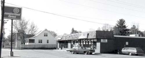
87 Lowell Road C 1977
For years 87 Lowell Road was the home of Etienne J. and Rose Levesque. This couple raised a family of 2 boys (Leo Paul and Robert) and 3 girls (Marie Anne, Eva, and Cecil). He was employed at and later retired from John Mansville in Nashua. Mr. Levesque passed in November 1968 with a family of some 17 grandchildren and 5 great grandchildren. During these years the family saw many changes along Lowell Road. Prior to 1962 Birch Street did not exist; by 1962 Birch Street connected Lowell Road with Winnhaven Drive.
Soon after his passing this “fine commercial site” at the southern corner of Birch and Lowell was cleared for development. A stately willow tree was sectioned and hauled away. The former Levesque home was raised off its foundation and moved 1/4 mile down Birch Street by local contractor, John Lester. This home remains today at 13 Birch Street as a private residence and the home of Richard and Shirley Nason and their family.
By 1970 a 3-store front building was constructed on this corner and occupied by Cumberland Farms, Anton’s Cleaners, and Russel and Son’s Carpets. Within a few years Anton’s relocated and Cumberland expanded into their space. The carpet place was replaced by Cardinal Reality and later by Hudson House of Pizza. This week’s photo, from the collection of the Historical Society, was taken about 1977 for publication in the history update, Town In Transition. Cumberland Farms and Hudson House of Pizza remained at this location until just a few years ago. This location is now occupied by Veria Pizza and Hudson Mini Mart.
Pre-Civil War Cannon at Library Park

Cannon at Library Park C 1942
This US Navy Cannon at Library Park and an identical one at The Hudson Center Common, sat for years on their respective concrete moorings. Children would play on then, walk up the steps of the mooring and sit horse-back on the barrel of the cannon. Many family and group photos have been taken on or around them through the years. Occasionally on Halloween, teens would decorate the cannons by pouring random colors of paint over the barrel. The cannons were soon repainted in black by the wandering teens at the request of the Police Department or else by the Highway Department or some service organization.
It is my understanding that these two 3-ton cannons were brought from the New Hampshire Armory on Canal Street in Nashua to Hudson in May 1929 through the efforts of Harry Emerson. One of them was placed on Library Park and the other at the Hudson Center Common. These cannons were cast in 1848 in a foundry near Boston and their serial numbers are within 2 digits of each other. The Library Park Cannon was fired but we are not sure if it was actually used in battle and if so, which battle. Harry Emerson was a long time resident of Central Street and at the time a custodian at the armory. He served the town of Hudson for over 50 years as a member of the Fire Department. Serving as Chief from 1946 to 1952.
The Library Park cannon remained silently on the park until September 2, 2015 when it was involved in a collision with a school bus which was the victim of faulty brakes. Fortunately there were no students on the bus and the driver was not injured. Realizing the brakes were faulty the driver steered the bus onto the park, grazed a tree, hit the cannon and stopped! The cannon itself was not harmed but the concrete mooring was pulverized. The cannon and debris were removed by the Highway Department.

Library Park Cannon 2016
For several months the cannon was at the town garage being sand blasted, restored, repainted, and a new mooring constructed. Earlier, in May of this year it was returned to Library Park; thanks to the efforts of our award winning Highway department; the recipient of the First Annual Community and Cultural Heritage Excellence Award sponsored by the Hudson Historical Society. Photos from the Society’s collection.
First World War Monument at Library Park

First World War Monument 2016
The First World War began in Europe during July 1914 and for the first years the United States had a policy of non-involvement. After the sinking of the Lusitania and the killing of some 190 Americans and later attacks on US ships, the United Stated declared war on Germany April 1917. The Armistice which lead to the end of conflicts was signed November 11, 1918.
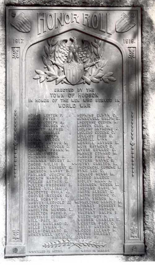
Bronze Tablet Listing Servicemen
Between 1917 and 1919 some 71 young men from Hudson were engaged in the Armed Forces. A listing of these servicemen was maintained by historian Julia (Webster) Robinson. At the town meeting in March 1920 the town voted to raise a tablet to honor these men and by early 1922 this granite boulder and attached bronze tablet was placed on Library Park by the Town of Hudson at a cost of $977.65. Of these young men 3 of then lost their lives during the conflict. On June 25, 1921 members oft he local Grand Army of the Republic (GAR) Chapter planted 3 maple trees nearby on Library Park near this monument as a memorial to Carlton Petry, Merrill Spaulding, and Leland Woods. Photos from the Historical Society Collection.
Railroad Overpass at Lowell and Central C1910
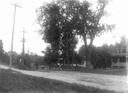
Railroad Overpass at Lowell and Central C1910
Taken from one of the glass negatives in our photo collection this is one of those amazing photos which tells its own story! The photo is from the photography of Walter Peavey who lived at 74 Central Street; later the home of Leon and Gerri Hammond.
The dirt road you see across the picture is Central Street near the beginning of Lowell Road. Of the two homes we see, the one on our left is currently 1 Lowell Road. The one on our right is 65 Central Street. Both Central Street and Lowell Road are dirt roadways. The steam railroad crossed the Merrimack River just below the Taylor Falls Bridge where the abutments can still be seem. On the Hudson side the tracks went north easterly and behind these homes and emerged at about the location of the former Hetzer’s Bike Shop. The train ran on the overpass you see in this photo and on to Hudson Center.
The trolley line crossed from Nashua on the Taylor Falls Bridge and ran on or along side Central Street and then down Lowell Road. The lower level of this overpass was used by the trolley line and vehicle/horse drawn traffic. Look closely and you can see the trolley tracks along Central Street.
Although both the train and trolley tracks had been removed by the 1940’s, the overpass and stone abutments remained into the 1950’s when they were also removed in order to improve what had become a dangerous intersection.
Railroad Overpass at Hudson Center
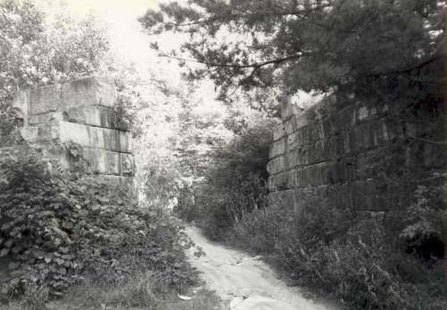
Railroad Overpass at Hudson Center
After crossing from Nashua into Hudson on the Taylor Falls Bridge, the street railway (trolley) branched in 3 directions. The first made a sharp turn down Webster Street and north to Litchfield and Manchester. The second proceeded up Central Street and on to and then down Lowell Road. The third, and the route of interest to us today, came up Ferry Street past Library Park. The trolley tracks remained on or alongside Ferry Street until the street ended at Burnham Road (near what is now Merrifield Park). At this point the trolley continued in a more or less straight line through the wooded and marsh area around Tarnic Pond. A relic of these tracks can be seen to the right of C.J. Chasers. The trolley line ultimately made a sharp right turn toward Central Street (route 111) emerging onto Central Street between Burger King and 7-11. It then crossed Central, onto the Benson’s property, and towards Bush Hill Road and the Haselton Barn.
The steam railroad crossed from Nashua into Hudson just a few rods south of the Taylor Falls Bridge, proceeded on a NorthEast path converging with Central Street near it’s intersection with Lowell Road ( site of Hammond Park). The railroad proceeded eastward towards Hudson Center crossing Burnham Road (called Betsey Cutter Crossing) on to part of Westview Cemetery and to the Station at Hudson Center at Greeley Street.
These 2 lines met behind what is now Burger King and to the right of The White Birch. At this junction the railroad went on the overpass and the trolley on the lower level. The overpass itself and the tracks for both the railroad and the trolley have been removed; leaving the huge granite blocks or abutments. This photo was taken C 1980 and is part of the Historical Society collection.
Town Seal and Flag

Town Seal 1965
We see the town seal prominently displayed on various town vehicles, in town literature, on the web site, and even used (with permission) by some town organizations. The seal, as show here, was first displayed on the back cover of The Hudson Annual Report for 1960. At the town meeting in March 1961 the voters adopted this seal as the official seal.Just prior to this Henry A. Fraser, a Hudson resident designed this seal at the request of Ned Spaulding, long time moderator of Hudson. He used a sketch of a typical garrison house from Webster’s History of Hudson as a basis for the center. The letters encircling identifies the incorporation date of 1746; when the town of Nottingham West (now Hudson) was chartered by New Hampshire. The original charter signed by then governor Benning Wentworth is preserved in the archives of Rodgers Memorial Library.
Mr. Fraser and his wife Gloria built their home and raised a family after he purchased land from the Merrill family on Maple Avenue. Professionally he was a wood worker and artist; employed by various companies in NH and Mass.
After adoption as the official seal a full color rendition was converted to a decal/print for use by and by permission of the Town of Hudson.

Town Flag 1975
The official town flag shown here was created as part of Hudson’s celebration of the US Bicentennial which began in 1975. A contest was held by the art department of Alvirne High School and a number of entries resulted. This particular design was selected as the winner and later adopted for the official town flag at the Town meeting of March 1975. The winning entry was by Terry Battey, then a senior at Alvirne. The design is simple but nice: the center being the same garrison house used in the town seal, surrounded by 9 stars signifying that New Hampshire was the 9th state to ratify the US Constitution. These were then placed in the center of a light blue flag. After the winner was chosen, some number of flags were made and displayed at commemorative events during the US bicentennial celebration, one is now on display in the corridor of the main floor in the Hudson Town Building. After graduating from Alvirne Terry attended Keene State College. She now lives in Auburn,NH and is busy with a full time job,and as a mother, and grandmother.
The rendition of the town seal shown here is from the 1960 Town Report; the photo of the flag is from 1975 Town Report
Minuteman Marker at Hudson Center Common 1975

Minute Man Marker Hudson Center Common
Shortly before midnight on April 18, 1775 a detachment of 800 British troops began their march from Boston to Lexington and Concord. The word of the impending battle was immediately sent by mounted messengers throughout the country; including the Merrimack Valley and Nottingham West, a distance of about 40 miles. Tradition says the news reached Nottingham West before noon of April 19 and mounted messengers again sent the word out to the various sections of our town. The message and the response was so quick that by that very same afternoon, 65 men equipped for war with muskets and ammunition had gathered at the Hudson Center Common ready to march to Lexington. These men were organized under the command of Captain Samuel Greeley and awaited his orders. The old military records are lost or destroyed but we do have the muster roll of this company of 65 men – all from Nottingham West. These men left for Lexington on the evening of April 19.
Before reaching their destination they were met by a courier who informed them of the retreat of the enemy. The command returned to Nottingham West. After this, many of these men enlisted in the army at Cambridge and at least 16 of them later fought at Bunker Hill in June of the same year.
Samuel Greeley was the oldest son of Samuel and Rachel Greeley. In 1740, at the age of 19, he came to Nottingham West from Haverhill and settled with his father on the Greeley Farm. This was a 200 acre farm just north of the Joseph Blodgett Garrison place on Lowell Road. Samuel married Abigail Blodgett, daughter of Joseph and Dorothy (Perham) Blodgett of the Blodgett Garrison in May 1744. He lived here until 1777, when at the age of 56, he and Abigail moved to Wilton; leaving the farm to his sons Joseph and Samuel. He died in Wilton. After his passing, his wife Abigail returned to town where she lived until the age of 95. While in Nottingham West Samuel was Town Clerk for about 28 years and on the Board of Selectmen for 14 years. He is remembered in our history as the Captain of the company of militia from Nottingham West who turned out 65 men as volunteers at the time of the Battle of Lexington April 19, 1775.
The Town Common at Hudson Center, originally about 2 acres of land, was used for many events including training for the town militia, Old Home Day activities, Chautauqua Programs, and recreation. In the early 1960’s the State of New Hampshire built the present route 111 through the center of the Common and eastward to West Windham. In 1962, the Board of Selectmen received a letter from the Hudson Fortnightly Club recommending that an historic marker commemorating the town’s minutemen be placed on that part of the Common which was not taken by the state for the highway. This was done by the town in 1963.
On April 19, 1975, some 200 years after the Battle of Lexington and as part of the United States bi-centennial activities a wreath was placed at this monument. For this event the carillon bells of the Baptist Church were played, and a floral wreath was placed by Phyllis Keeney, Selectman and a Past President of Fortnightly. The floral wreath was made by club member Mrs. Florence Bogan. Following the raising of the American Flag with color guards from Veteran’s Auxiliary and Girl Scouts and the singing of the National Anthem by Mrs. Bruce Cole, the Muster Roll of the 65 men was read by John Beaumont. A benediction and playing of God Bless America on the carillon bells closed the activities. This marker is located at the point of land on the common near Kimball Hill Road at the intersection with Central Street. Photo from the Historical Society collection.
Blodgett Garrison Marker

Blodgett Garrison Marker
Of the four garrisons constructed for the protection of early settlers in Nottingham, Mass, we have discussed the Hills Garrison. Moving south from the Hills garrison was the Taylor Garrison built on land which was originally part of the Joseph Hills grant, passed to a family member and then sold to John Taylor. Very little is known about John Taylor except that the Taylor Falls and thus the Taylor Falls Bridge bear his name. The location of his garrison was not marked by Kimball Webster but was identified by him as behind the Spaulding Farm on Derry Road (now Continental Beauty School) and along side Grand Avenue in the direction of the river.
Moving south the next garrison is the Blodgett Garrison. Kimball Webster placed the site 2.5 miles south of the mouth of the Nashua River and 1/2 the distance between Lowell Road and the river. The marker was placed on the Philip J. Connell Farm in 1905. The Connell Farm was a part of the original 200 acre farm of Joseph Blodgett. Today this is the general area around Fairview Health Care on Hampshire Drive. The granite boulder with a bronze tablet now resides on the lawn of 14-16 Hampshire Drive just east of Fairview.
After Joseph and Dorothy Blodgett settled here their oldest son Joseph was born in Feb 1718; he was the first white child (as opposed to Native American) child born in our town. Both Joseph and Dorothy were born in Chelmsford. Most likely the family traveled up the Merrimack River by canoe to settle their farm. Their descendants became very numerous and includes many distinguished men and women in NH, Mass, and other states.
The last garrison, was located on Fletcher land and was in that part of Nottingham which remained in Massachusetts when the provincial boundary was established. The location is a short distance south of the state in Tyngsborough. The photo of the Blodgett marker is from the Historical Society Collection.
Garrison Farm at 187 Webster Street

Garrison Farm at 187 Webster
While researching the initial location of the Hills Garrison Marker for last week’s photo, I was reminded of this aerial photo of The Garrison Farm at 187 Webster Street. The garrison marker was placed by Kimball Webster in the open field a short distance east (to the right) and down the farm road between the barns. At that time, in 1902, this farm of about 60 acres was owned by Justin M. Sleeper and operated by himself and his son-in-law Joseph Howard Legallee.
Earlier and following some medical issues Joseph Howard Legallee could no longer continue his work as a paper hanger. It was decided that he and his father-in-law Justin M. Sleeper would go into farming together. In 1891 Sleeper purchased a farm from John M. Thompson on what is now the Marsh Road. This farm later became the Marsh Place and the site of the present golf course. Joseph Howard Legallee, his wife Eva, their 2 year old son Howard Sleeper Legallee and his father-in-law Justin Sleeper moved to Hudson. By 1900 they sold the Marsh Road farm and purchased the Hill(s) Farm of about 60 acres on Webster Street at the intersection with Derry Lane. This farm included 20 tillable acres and a house in need of repair. The farm fields were in the river valley and extended on both sides of Webster Street. On the west they stretched to the river bank. On the east was the house, pasture for the family cows, and a year-round brook which provided a gravity fed water source for the family home, the farm, as well as water source to the Ferryall Farm (later the Rowell Farm and now Sparkling River) as well as The Hardy Place at the end of Elm Avenue (now the home of Dr. and Mrs. Brody). The Sleeper/Legallee family remained on and expanded the farm operation for 3 generations until about 1950 when the farm was sold to Colby Brothers.
As a farm it changed hands one more time about 1959 when it was operated by George Colby, Jr and Taze “Mac” McPherson. This weeks photo was taken some time after 1959 but before George and “Mac” built the Garrison Farm Stand just south of the farmhouse. The farm stand became a ready source for locally grown produce. By the late 1980’s and into 1990 subdivision of the farm occurred. The west field became a residential development (Scenic Lane and Shoreline Drive) and the east side became both residential and commercial. Currently a small convenience store and landscaping business has developed from the farm stand.
Prior to the 1900 purchase by Sleeper/Legallee this farm takes its roots back to 1661 as it was the northern most part of the land granted to Joseph Hills by the Province of Mass. Joseph willed this northern parcel of about 89 acres to his son Samuel. In turn 3 of Samuel’s’ sons – Nathaniel Henry, and James built a garrison and settled here about 1710. It remained a Hill(s) farm until 1900.
A number of Hudson locals remember the farm stand under ownership of George and “Mac”. As owners they continued to truck produce to markets but also marketed their produce locally. A few residents may even remember the ownership of Howard Legallee, his wife Phoebe, and their daughters Shirley, Beth, and Frances. It was Howard Legallee who transitioned the farm from a family dairy farm into a productive market garden. This began as early as 1913 when Howard completed a special course in agriculture at UNH Durham. He specialized in potatoes and later potatoes and sweet corn. One year his production reached 4500 bushels of potatoes. With the addition of irrigation and the proper storage barn he was able to sell potatoes year round.

Legallees Float 1939 Parade
Foremost in what I have read was their participation in the 1939 Old Home Day parade with a huge potato pulled on a flat bed trailer by Howard on his John Deere tractor. The family worked together on this float; constructing a potato from canvas, colored brown with eyes, sewn into the shape of a potato and stuffed with hay. Both photos from the Historical Society Collection.
Hills Garrison Marker

Hills Garrison Marker
Four garrisons were built within the town of Nottingham, MA as a protection against the Indians at the start of or during the time of Lovewell’s War. A garrison consisted of a two-story dwelling surrounded by a stockade style fence with one opening. The second story of the dwelling extended out over the first story so the settlers could look down and fire upon any intruders below.
The earliest and most northerly of these garrisons was settled about 1710 on land then owned by Samuel Hills of Newbury, MA and settled by three of his sons, Nathaniel, Henry, and James. Kimball Webster, town historian, determined the location of the Hills garrison and placed a granite boulder to mark the location in 1901. This marker was originally placed 25 rods east (412 feet) of the Litchfield Road on a farm then owned by Joseph H. LeGalee. Often called Garrison Farm, this farm remained in the LeGalee family for three generations and became a large market garden; it was later operated by Colby Brothers. The stone marker was easily accessible and visible to those working in the fields. As progress occurred and the use of the fields changed to industrial there was concern over the safety of the marker and it’s interference with the development of the area.
In 2008 when Hills Garrison School was completed and so named, the marker was removed from the Garrison Farm location. The photo of the Hills Garrison Marker shown here was taken at its present location along the entry road to Hills Garrison School. There is a mystery about this marker for which I do not have an answer. Three brothers, Nathaniel, Henry, and James built and settled in the garrison about 1710; however, Kimball Webster when he erected the marker only mentions the older 2 brothers, Nathaniel and Henry. Why was James omitted? Could it be because at the time he was just a lad of about 13 years of age?
The Hills Garrison was built upon a 45 acre parcel which Samuel Hills had inherited from his father Joseph in 1688; a part of Joseph’s original 500 acre grant from the province of Massachusetts. Neither Joseph or Samuel settled on their land. But, the ensuing families of Nathaniel, Henry, and James became the foundation of all the Hills development and family in Hudson and many of the surrounding towns. Photo from the Historical Society collection.
