Disasters known as “Freshets” and Fires

This week a brief look at the floods of 1896 and 1936 as well as the Crown Hill Fire in 1930 and how Hudson residents became spectators to these events.

2011029001

Flood Watching on Iron Bridge 1896


Floods, or ‘freshets’ as referred to by Kimball Webster in his History of Hudson, were common events along the Merrimack River and were recorded in his history of our town. This is particularly true in the bridge area with the mouth of the Nashua River just a few rods to the north. Coupling this with the spring rain fall along with snow and ice melting from the north and west contributes to flooding and the potential for the destruction of property. In the 1800’s notable freshets were recorded in 1818, 1824, 1839, 1841, 1843, 1852, and 1862. In April 1895 a freshet occurred which raised the river to a higher point than any for many years. The east bank of the Merrimack opposite the Nashua River overflowed and covered land along Webster Street.

Our first photograph shows residents of Hudson watching the flood water of the river from the recently constructed iron bridge during the freshet of March 1896. Just before midnight on March 2 the river gained its highest point and began, slowly at first, to recede. The weather turned colder the next day allowing the water to fall very rapidly. At the highest point the water covered all of Webster Street directly west of Kimball Webster’s house. The flood water rose to within six feet, six and one half inches from the underpinning of his house near the front door. Near the iron bridge the surface of the flood was between three and four feet below the floor of the bridge.

On Sunday May 4, 1930, in the early years of the depression, many Nashua residents were suddenly made homeless by a huge fire which destroyed the Crown Hill residential area. This area was East Hollis and Allds Streets eastward to the bank of the Merrimack River, just a short distance south of the Taylor Falls bridge in the area of the railroad bridge.

The blaze began in a trestle of the B & M Railroad where it spanned the Nashua River off Temple Street. High winds escalated the blaze and carried the fire across Temple, down Spruce, and across East Hollis Streets to the Crown Hill area. Fire equipment from surrounding towns in both New Hampshire and Mass. came to assist. Individual residents pitched in with bucket brigades, shovels of dirt, and even blankets. In the end some 400 homes were destroyed and that section of Nashua reduced to wasteland. Most of the property owners had little or no insurance. One year after this disaster more than 400 homes were rebuilt and the area was making a comeback with new zoning and wider streets.

2013037037

Hudson Residents Viewing Crown Hill Fire 1930

Homes and property in Hudson were protected from the spreading blaze by the Merrimack River; although there were some instances where sparks jumped the river, due to the severe winds, and had to be extinguished. As shown in our second photo, some Hudson residents set up their chairs along the Hudson side of the river and became spectators to the fire.

In March 1936 the most severe flood for this area occurred. By Thursday morning, March 19, the Taylor Falls Bridge was closed to traffic as the banks of the Merrimack were overflowing with tons of water on both sides of the river. At 7:00 A.M. the river was rising at the rate four feet per hour. Residents living near the bridge were forced to evacuate. Officers were stationed at both ends of the bridge to stop traffic.

Families along Webster Street and Litchfield Road were evacuated. The Paradise section near the river (Kenyon, Merrimack and Federal Streets) was completely flooded and the fire department evacuated residents by boats. In the areas mentioned, water rose to the first floor windows.Extensive flooding occurred at all homes along the Webster Street and Litchfield Road.

During the height of the flooding, a log coming down the river did so with such force that it banged head long into the railing of the cement Taylor Falls Bridge. This left a permanent hole in the railing, removing the concrete, and showing only the underlying mesh. From that day until the removal of the bridge, the damage was never repaired. It remained as a reminder of the of the potential force of the river current.

1977002009

Flood Waters 1936

Again, our fellow residents of town chose to walk on the bridge and observe the flood water barreling into the bridge on it;s north side. Needless to say, this occurred either before or after the height of the flood. Water was ether receding or still trying to reach it’s maximum height. Our third photo shows Hudson residents leaning over the north side of the bridge as the flood water approached the bridge.

B+M Railroad Bridge blasted by Army manuevers – Dec 1942

2013037014

B+M Railroad Bridge Crossing Into Hudson – 1938


The Worcester, Nashua, and Portland line of the Boston and Maine Railroad began operation through Hudson in 1874 and continued until abandoned in the early 1940’s. The railroad line entered Hudson by crossing the Merrimack River just south of the present Taylor Falls bridge between Nashua and Hudson. The line then took a gradual north and easterly path to Hudson Center and then on to West Windham.

The original wooden railroad bridge was completely destroyed by fire in June 1909 when sparks from an east bound freight train ignited one of the timbers. The resulting blaze was so spectacular that an estimated 1,000 folks in the area watch the blaze against the midnight sky. The destruction of this bridge seriously interfered with the traffic between Worcester and Portland; some 32 trains per day used this bridge daily along the single track line to West Windham and Portland. A temporary bridge was put in place within a week and a replacement steel bridge was completed in record time.

By December of 1942 the days of this line had ended. It was decided to use this steel railroad bridge for army maneuvers. On Saturday December 26, 1942 two preliminary blasts of dynamite were set off near the Nashua side of the bridge. These were staged to acquaint the military unit with the explosives. A detail from Maryland was delegated for this task. According to the Nashua Telegraph the Army Engineers planned at some later time to conduct extensive maneuvers ending with the blowing up of the bridge. According to officials of the railroad, the railroad bridge had been turned over to the U.S. Army about one month earlier.

These explosions occurred without warning to or previous planning with local officials. The first blast consisted of 50 pounds and a second of 150 pounds. Residents of the Crown Hill section of Nashua as well as of the Hudson Bridge area were frightened and hundreds of phone calls were made to police and fire headquarters as well as to the local paper. The resulting explosions rocked houses and blew out hundreds of panes of glass. Many residents were in a near panic and several women were hysterical.

Complaints and protests occurred on both sides of the river. Scores of residents from Crown Hill district reported window broken and other damage. On the Hudson side many windows were blown in and plaster was shaken down in many of the homes. Significant damage was reported to the windows and frames of the Hudson Community Church. The effects of the blasts were felt as far away and Benson’s Animal Farm in Hudson Center.

Needless to say both Nashua and Hudson officials registered their protests through Senators Bridges and Tobey. The senators conducted an investigation into the blasts. Army personnel from Fort Belvoir, MD as well as First Corps Area were called back for the session. First Army Corps of Boston claimed they had no prior knowledge of the maneuvers. No advance warning of the blasts had been given. Much, of the damage and emotions could have been controlled with advance knowledge of the blasts and simply opening the windows just prior to the last. Army officials met with Hudson Selectmen and property owners in order to access the damage. Shortly thereafter forms were provided to the property owners for reimbursement of damages. Reimbursement for at least part of the damages by the U.S. government did occur up to 1 year later.

Once the Senators and officials from Nashua and Hudson learned that these blasts were preliminary to blowing up the bridge with a 500 pound charge at some future time an official protest to further blasting was registered. It was pointed out that it made more sense to salvage the bridge for scrap material for the war effort than to blast it and sink it into the river.


In October 1943 salvaging of the bridge began when Governor of New Hampshire, Robert C. Blood, applied the torch to the first steel girder of the old railroad bridge. In the end, 500 tons of steel were scrapped and turned over to the State Salvage Commission to be used in the making of war materials. By January 1944 the old railroad bridge was gone. All that remains of this bridge today are the old abutments in the river, visible just south of the Taylor Falls Bridge.

This photo is from the Historical Society collection. It shows the railroad bridge during the hurricane of 1938; just a few years before the army maneuvers to blast the bridge. In this photo a train was stationed on the bridge during the hurricane to stabilize the bridge. Details of the blasts, resulting damage, and the probes were reported in the Nashua Telegraph for Monday December 28, 1942.

Scottie Industries on Roosevelt Avenue

1977004017

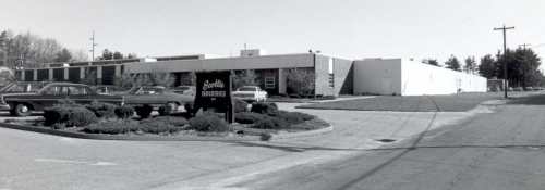
Scottie Industries Roosevelt Ave. C 1975

Researching the history of an area makes one aware of the changes which occur over time.  This is as true with  Hudson as perhaps any other town; particularly along our major roadways like Lowell Road where we have seen a major shift from  agricultural use to industrial use.  By the 1960’s land use was changing and land values were on the increase.  As a result taxes were also on the increase and local farm families  were finding it harder and harder to earn a living.  Younger generations were attracted to good jobs and professions off the farm.  At the same time the older generations were of retirement age and were attracted to selling their land at what was, for that time, a good profit.
By 1969 a small industrial area off of Lowell Road on  Roosevelt Avenue was under construction.  By the summer of 1970  Scottie Industries, Inc was operating a plant for manufacturing canvas footwear.  The facility included a warehouse, office area,  and an outlet store. For the employees and their families Scottie’s also had a 42×18 foot indoor swimming pool maintained by reliable personnel.   New Hampshire and Hudson offered an excellent business climate:  lower acquisition costs, lower taxes, and an available labor force.    Many from Hudson, particularly women, were employed here.  In time full operation was moved to Hudson from Lowell, MA.  Scottie’s also had a line of custom neck ware.
Scottie Industries remained in operation into the 1990’s when once again we see changes brought on from competition from larger shoe/sneaker manufacturers.  The building at 8 Roosevelt Avenue is currently used as a warehouse  for Ashley/Ashbrook Furniture.
This photo of Scottie Industries on Roosevelt Avenue was taken c1975 for use in preparation of “Town In Transition”.

Frank A. Winn Farm on Lowell Road

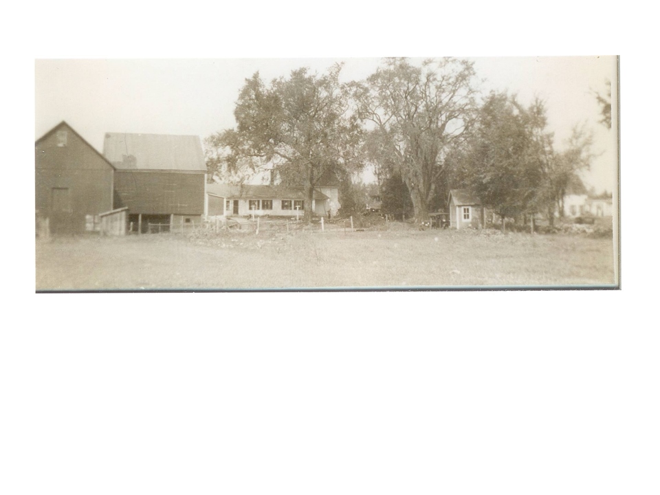
Home of Frank A, and Effie May Winn

This week we visit the homestead of Frank Almon and Effie May (Wyeth) Winn on Lowell Road.  Frank moved to Hudson  from Pelham with his parents, Franklin A. and Lizzie Winn, about 1883 when he was 8 years old.  His family purchased  a farm of over 70 acres which stretched from Lowell Road to the river.  Across one part of the farm was a large brook which traveled through fields and woods, making it’s course through the rocky gorge to the river.  This is where Frank played, grew, and worked with his family.  By today’s landmarks, this farm includes most, if not all of , the land between Winn Avenue and Winnhaven Drive (between 35 and 49 Lowell Road)   and extending westward to the river.  Between these roads and adjacent to Lowell Road was a large tilled field  for growing  vegetables for market.  The family home with the large attached barn was located at what is now 1 Winn Avenue and faced this field.  On December 24, 1958 the barn was destroyed by a spectacular fire.  The fire fighters were able to save the house.
As a young man Frank made his way across the United States, but he soon returned to his home here in Hudson.  Along with his parents, he tilled the farm fields all his life.  In due time he came into possession of the farm.  In September 1915 he and Effie May Wyeth  were married; and it is here that they raised their family.  Frank was a tireless worker with both his hands and his head.  He not only knew about agriculture, he also knew about the wider world of business and economics.
 
Effie May was born in Nashua, May 1886, and educated in Nashua schools and Keene Normal School.  Prior to their marriage in 1915, she taught school in Nashua.  She later did substitute teaching in Hudson, Pelham, Merrimack, and Nashua.  Frank and Effie May raised a family of 3 girls; Lillian Emma (b: about 1918),  Effie May (b: about 1921) and Frances (b: about 1923).
Frank passed in September 1935, at the early age of 60; Effie May and her daughters continued to live at the homestead.  By the end of 1942 all three daughters were married.  Lilliam Emma was married to Walter Schindler; Effie May married Clayton Oban; and Frances Stebbins married Alton Drown.  Mrs. Winn, Effie May, was a resident of Hudson most of her 97 years.  She passed in 1983 at the home of her daughter Frances (Drown) Hosmer, with whom she had lived for a few years.  Many Hudson residents remember Effie May; particularly with her involvement with the Hudson Fortnightly Club for over 50 years.
 
As time advanced and the land usage changed, the Frank A. Winn farm was developed.  At first with the apartments and residential buildings in wooded area and adjacent to the river.  Later the farm field between Winn Avenue and Winnhaven Drive were developed.  The earliest development occurred in 1963 with the construction of LNL Bowl at what is now 8 Winn Avenue.  Named for the three owners:  Earl Libby, Leon Noel, and Adrien Labrie; LNL bowl offered candlepin bowling lanes, a sport unique to New England,    The lanes operated until 1978.  By 1979 this site became the home of Dessault Engineering Associates. It is now home to Opti-Sciences.
By 1964 construction began for the first of many restaurants to operate at 49 Lowell Road, likely owned by members of the Winn Family.  The Winstead Restaurant  began operation in 1965.  By 1969 this was the site of Hayward Farms Restaurant.  Over the succeeding years a number of restaurants were located here.  From what I can piece together the list is as follows:  1972 – Pizza by Giovanni; 1980 Straw Hat Restaurant; 1984 Primo’s.  Following Primo’s there were Ziggy’s, Stevie P’s, Yaght Club, Charman’s, and presently SOHO.
Construction for Nashua Federal Savings and Loan at 45 Lowell Road began in 1979.  A bank has remained at this site; becoming Bank of America and more recently Enterprise Bank.
More recently, two additional sites have been developed.  First the retail/office mall at 43 Lowell Road known as Bell Tower plaza.  The second is the two unit mall at 35 Lowell.  This later unit was actually constructed on the portion of the original parking area for LNL Bowl.
The Winn House at 1 Winn Avenue razed about 2006 and replaced with the current building.  The first occupant was European Deli with a speciality menu including European style ice cream, coffee, and sandwiches.  It has since been used as Tokyo Joe’s Karae Studio.  It is currently doing business as Dojo Sante; karate, kickboxing, and fitness.
Our photo is courtesy of the Winn Family and is a part of the Historical Society Collection.

Cemetery of the Unknown

Peremiter fence cemetery of unknown

Perimeter Fence

The Cemetery of the Unknown was a part of the town poor farm  located in the north west section of Hudson on what is now Old Derry Road.  For this cemetery there are no monuments, no headstones, and no records to identify the individuals buried there.  The farm was purchased by the town in 1828 in the days when the resident poor were kept at the town farm.  Those who could worked the farm in an effort to produce food for all residents on the farm.  The town maintained this farm for some  40 years until 1868 .  At that time the farm was sold and the few paupers which did exist at the time were boarded out to private homes at the expense of the town. The  only known records of activity at the town farm was recorded by the Overseer of the Poor in the annual town reports.  It is estimated from these records that over the course of 40 years the  number of residents at this farm varied from 6 to 12 per year.   Any of them who spent their final months at the farm likely found their final resting place within the Cemetery of Unknown.  Some of these folks had been prosperous citizens of Hudson  but due to reversal of fortune  or conditions, spent their final times here and were laid to rest in the yard at the end of the farm.
The number of deaths which occurred here during these 40 plus years in not known; but it is estimated there was an average of at least 1 per year.  There are no records to indicate who they are, when they passed, and where within the cemetery each was laid to rest.
As time progressed  the land upon which the burial yard existed continued in private use.  Fewer and fewer residents of town retained any memory of this cemetery.  Perhaps the stage was set for the Cemetery of the Unknown to be lost to history forever.
100 years after the town poor farm and the site of the Cemetery of the Unknown was sold by the town of Hudson, Paul Gauvreau and his family purchased their homestead on Old Derry Road.  In talking with family of the previous owner, Paul was told about the Cemetery of the Unknown and that only a few people were still alive to remember that it existed; soon it would be grown over and all traces of the cemetery gone forever.
In 1982 plans were made to construct a new road, Twin Meadow Drive, and to build a number of duplex residences.   Aware of the existence of the cemetery but not sure of it’s exact location, Paul informed the Hudson Planning Board of the cemetery.  The developer agreed to stop excavation if burial sites were unearthed.  None were found and several duplexes were constructed along Twin Meadow Drive bordering the  field off Old Derry Road.
In 1990, Paul along with some of the  neighbors on Twin Meadow Drive did some local detective work  in the fields behind Twin Meadow Drive.  After removing brush and mowing the tall grass on a flatter section of the field, they discovered what appeared to be several sunken grave sites.  These depressions measured about 2 1/2 feet wide and about 6 feet in length and faced east and west; consistent with grave sites.  The depressions were likely caused by the collapse of the wooden enclosures over the years.  Paul contacted the town Executive Administrator, town Planner, and the Town Librarian .  Upon visiting the site, all agreed the site was worthy of further study; but, since the form of town government was about to change, all agreed to postpone the matter until the new government was in place.
Paul researched the Hudson town reports for the years 1845 through 1870; specifically the Reports of the Overseers of The Poor which lists the activities and financial transactions of the Poor Farm.  It should be noted that reports from 1828 through 1844 were not available.  He was able to compile a list of some 32 names of  individuals that died as paupers associated with the poor farm during these years, either living at the farm or being boarded in private homes at town expense.  Of these 32, 3 were buried in Nashua or Litchfield.  Most, if not all if the remaining 29 were buried on the farm. It is not possible to discover the exact number or identity of the individuals laid to rest in this cemetery during it’s 42 years of operation. The names we do have include individuals from well known Hudson families:  Barrett, Hamblet, Johnson, Marsh, Parker, Robinson to name a few.
In August 1994, as agreed with the town officials, Paul contacted Mr. Gary Hume, State Archaeologist, and asked him to conduct archaeological probings.  These probings and investigations took place during the fall months of 1994.  Present at each of these sessions were representatives from the state, officials from Town of Hudson, the Historical Society, various neighbors in the area, and Paul Gauvreau.  Paul had previously shared the results of his findings with both town and state representatives.  In March 1996, the New Hampshire Division of Historical Resources issued a report of their findings to Hudson Cemetery Trustees.  In essence this report confirmed the location and existence of the Cemetery of the Unknown.  The report did not make specific recommendations as to how this cemetery should be preserved; but did direct the town of Hudson to proceed with the recognition and protection of the property. In the months to follow, the town of Hudson led by the Cemetery Trustees, purchased from the landowners the Cemetery of the Unknown (also known as Poor Farm Cemetery) along with an access easement from Twin Meadow Drive to the cemetery.  On September 1, 2007 the cemetery was dedicated and a single monument placed there in memory of the estimated 62 individuals buried there over the years.
Monument at cemetery of unknown s

Single Monument for All 62 Nameless

The author and Paul Gauvreau visited the cemetery this past weekend and met with Susan Bauman whose home abuts the cemetery.  Both Paul and Susan have maintained chronology of events leading up to the confirmation and dedication of this cemetery.  Our thanks to them for sharing information with us.

Holy Cross Cemetery on Ledge Road

Holy Cross Cemetery S

Entry Sign and Flagpoles at Holy Cross Cemetery in Hudson


The Church of the Immaculate Conception at what is now 119 Temple Street, Nashua was consecrated in 1857 as an Irish Catholic Community. By the early 1900’s the Lithuanian Community was on the increase and a pastor was added to this church to minister to them. As both communities continued to grow it became evident that a new church was needed. By 1909 the Irish Community moved into the newly constructed Saint Patrick’s Church on Spring Street. Soon thereafter The Church of the Immaculate Conception was transferred to the Lithuanian Community and the name of the church changed to Saint Casimir’s in honor of the Lithuanian saint.

One of the first additions made by Saint Casimir’s church was the purchase of property on Ledge Road in Hudson for a cemetery; Holy Cross Cemetery. At the entrance to this cemetery from Ledge Road there are two flagpoles: one flies the US Flag the other the Lithuanian Flag.

Saint Casimer’s church was closed in 2003 and the congregation merged into Saint Patrick’s on Spring Street. The property at 119 is now Casimir’s Place, an affordable housing complex. Holy Cross cemetery retains it’s original name but the management and operations have been combined with Saint Patrick’s Cemetery. In a sense the congregations of Saint Patrick’s and Saint Casimir’s have gone full circle. Originally the Irish and Lithuanian congregations shared The Church of the Imaculate Conception on Temple Street. As congregations grew, the Saint Patrick’s Church was built on Spring Street and the Lithuanian community remained on Temple Street as Saint Casimir’s. Some 90 plus years later in 2003, Saint Casimir’s has merged with Saint Patrick’s.

Initially this cemetery offered burial space to members of the Lithuanian community. Until recently the policy of this cemetery was to offer burial space to members of the Catholic community. This has changed and space within Holy Cross, like Saint Patrick’s, is available to any member of the Christian community. The contact person is Elaine Poulin at 881-8131.

The photo of the entrance to Holy Cross was taken by the author and is part of the Historical Society collection.

The Catholic Cemetery (Saint Patrick’s) on Derry Road

St Patricks Cemetery Entry S

St Patricks Cemetery Derry Road

The availability of jobs resulting from industry and factories coming to Nashua resulted in an increase in the immigrant population of Nashua.  The Catholic Church quickly recognized the need to have pastors and congregations available for these communities.  In the 1850’s Nashua experienced a great influx of Irish families, pushing the construction of The Church of the Immaculate Conception on Temple Street.  At the time of it’s consecration in  1857,  2,000 communicants were added to the church rolls. 

By the early 1900’s the Lithuanian Community was likewise on the increase and a pastor was added to The Church of the Immaculate Conception  to minister to them.  As both communities continued to grow it became evident that a new church was needed.  In March 1891 the church purchased the Hosmer Estate on Spring Street and by 1909  services were being held for the Irish Catholic Community at Saint Patrick’s Church on Spring Street.    
 
Soon after 1909 The  Church of the Immaculate Conception  was turned over to the Lithuanian Community and the name of the church changed to Saint Casimir’s.
 
 On or about 1857 ten acres of land on Derry Road in Hudson was purchased  by The Church of the Immaculate Conception and consecrated for the purpose of a cemetery for the Irish community.   The original land was conveyed by the Pierce Family of, James L, John P, and Edgar B, residents of Nashua.  With the exception of about one acre on the east side which was swampy and unfit for use as a cemetery, lots were laid out. In 1907, a strip of land was purchased on the north side and an enlargement made to the cemetery. By 1912, at the time of the writing of Webster’s History of Hudson, nearly all the lots had been taken up.  The vast majority of the interments within this cemetery were for families residing outside of Hudson. Our first photo shows the hillside as you enter the cemetery.  After the archway with the name of the cemetery is the sacred cross followed by the War Memorial and the American Flag.
Celtic Cross St Patricks

Celtic Cross at St Patricks

 
Acting as a sentinel and gateway to the newer section of the cemetery behind Hannaford’s Super Market is this Celtic Cross, in memory of  R. T.  Rev. Monsignor Matthew J.B.Creamer, the Pastor of St. Patrick’s Church from 1906 – 1939.  
 
Initially this cemetery was to offer cemetery space to members of the Irish community.  By 1895, the Catholic cemetery contained about 4,000 graves sites; the vast majority were for the Irish Catholic community, but a few hundred French Catholics were also interred here.  After St. Patrick’s  Church on Spring Street was built the name of this cemetery was changed to Saint Patrick’s.  Until recently the policy of this cemetery was to offer burial space to members of the Catholic community.  This has changed and space within Saint Patrick’s is available to any member of the Christian community.  With the recent expansion there are lots available.  The contact person is Elaine Poulin at 881-8131.  


Westview Cemetery on Burnham Road

OLYMPUS DIGITAL CAMERA

Westview Cemetery Burnham Road


When the Old Hudson Center Cemetery, located on the Common, became nearly covered with graves, the need for additional  cemetery  space in that part of town became apparent.  The Hudson Center Cemetery Association published their intentions on the Oasis, a newspaper published in Nashua for three weeks in a row, in accordance with the laws of the State of New Hampshire.  An initial meeting was held at the town house in Hudson Center, now Wattannick Hall, on December 4, 1849.  At this meeting a set of by-laws and a slate of officers were elected.  Elected as Directors were Jefferson Smith, Joseph Dane, James Smith, 2nd, Dustin B. Smith, and Daniel W. Robinson,  Eli Hamblet was elected Clerk and Amory Burnham as Treasurer.


The initial acreage for the cemetery was donated by Reuben Greeley.  This parcel is located to the right as you enter the cemetery gate from Burnham Road.  The cemetery was laid out into large lots, most of which would allow for 12 burials so as to accommodate large families and multiple generations.  Between each lot space was allocated for walkways.  The layout also included streets wide enough so that  horse and wagons, and  later vehicles could enter the cemetery.  All of this was located less than one half mile from Hudson Center.


After the Nashua and Rochester Railroad was constructed, a substantial addition of land was made to the cemetery.  All the land between the initial parcel and the southerly line of the railroad land was acquired, making a total of nearly three acres.  After the railroad ceased to operate, the cemetery purchased  the right of way from the railroad.  This right of way is clearly visible today and is used as a short cut from Burnham Road to Hudson Center.


So as not to confuse this new cemetery with the Old Hudson Center Cemetery it was called Clement Cemetery.  I am not sure why this name was associated with this yard; but, it is often referred as such in the old records.  The name Westview has since been adopted and it is known by that name today.


Within this cemetery one will find the final resting place for many Hudson families of the last 167 years.  One will also find a number of lots with beautiful and expensive monuments; as well many of the more common markings.  Records of the cemetery also indicate burials in some of the lots where no visual monuments were placed by the surviving families.  But, thankfully, knowledge of their burials has been preserved by the written records.


I find the most elaborate monuments within Westview to be along the back wall of the old section.  These belong to the families of Dr. David O. Smith, Dr. Henry O. Smith, and the Haselton family from Bush Hill.  The oldest burial is that of Betsey Beard who died June 1850 at the age of 80.


The most  interesting burial site is the unmarked grave of Rev. Benjamin Dean, a minister serving the Baptist Church from April 1828 to June 1830; at which time he left the ministry but remained a resident of Hudson Center and continued to live in  his home on Hamblet Avenue.  When he passed in 1856 he was buried in the Potters Field section of the cemetery.  Many years later when additional lots were laid out, the Potters Field and his burial site was included within one of the new lots.  But, the location of Rev. Dean’s burial site has not been lost to history.  It remains unmarked; but, has been included within the written record of this newer lot.


The photo showing the entrance to Westview Cemetery at 20 Burnam Road was taken by the author and is a part of the Historical Society Collection.

Sunnyside Cemetery on Central Street

Sunnyside Entrance S

Entrance to Sunnyside Cemetery on Central Street

As the town grew and burial space in the older cemeteries became limited, the need for Sunnyside Cemetery arose.  According to the incorporation papers the legal name of this yard is ‘The Hudson Cemetery”.  The Sunnyside cemetery as it is commonly refereed to is located on the north side of the highway at 98 Central Street.   According to records, the original yard purchased from William Hadley in June 1846 was slightly over 1/2 acre.  The land was purchased for $13.00 and an additional $257.00 to Ethan Willoughby for the construction of the stone wall which enclosed the yard with an entrance off Central Street.  There were two  additional land purchases, one in 1885 and the second in 1910.  After the first purchase the stone wall was moved to include the parcel within the bounds of the yard.  At the present time this small cemetery contains 2.817 acres shaded from the canopy of maple trees.
According to Kimball Webster in his History of Hudson,  the first meeting of the Hudson Cemetery Association was held at the home of Ethan Willoughby on Central Street  December 6, 1845.  At this meeting the cemetery was organized, and the articles of association were signed by Ethan willoughby, Paul Colburn, Cyrus Warren, Nathan Marshall, William Hadley, David Clement, David Burns, Abiather Winn, Mark Willoughby, Benjamin A. Merril, and William Blodgett,  It was also agreed to purchase the original 200 by 113 feet original parcel for the cemetery.  No record of any subsequent meeting for several years; however business was conducted and the land was purchased, lots laid out,  and stone wall built  by 1851.  
 
The very first lot, number 17, was sold to Alfred Cummings on April 8, 1851.  By 1885 all the lots in the cemetery had been sold and during that same year a second land purchase of 1 acre was added to the cemetery on the east side and the wall was moved so as to enclose it.  The new ground was laid out into lots and the size of the cemetery more than doubled.  By 1908 all the lots in this section had been sold.  Again in 1910, a 1/2 acre was purchased from George Marshall, allowing expansion to the rear of the cemetery.  this land was subsequently improved and laid out into lots, all of which have been sold.
Joseph Fuller Monument

Joseph Fuller Monument

Sunnyside  is an attractive cemetery with a convenient location.  It contains a number of expensive and interesting monuments.   To me, the most elaborate monument is that for the families of Kimball Webster and his Brother Nathan.  This monument greets you on the right as you enter the yard.  The most interesting monument is that for Joseph Fuller (1818-1896) and his wife Belinda Steele (1823- 1891).  This metal monument is shown in our second photograph and  resembles a fireplace.  It is on the right side of the yard about halfway to the rear.
Unfortunately, the surrounding area does not include any possibility for expansion.  It has become the final resting place for many of Hudson’s families such as Baker, Batchelder, Chase, Colburn, Cummings, Davis, Gould, Hadley, Holmes, Martin, Marshall, Pollard, Sanders, Sargent, Stearns, Steele, Willoughby, Winn, and Webster.  At the present time the management of Sunnyside Cemetery in handled by Fred Fuller.
The photo of the entrance to Sunnyside was taken by Lorna Granger, a neighbor to the cemetery.  The photo of the Joseph Fuller monument was by the author.  Both will be part of the Society’s collection.

.. Hudson Center Cemetery

Hudson Center Gate1

Hudson Center Cemetery Gate

Actually, the next Hudson cemetery in terms of age is the Senter cemetery which we visited a few weeks ago when we were exploring Old Derry Road,  Remember, interments at the Senter site occurred as early as 1759 while this part of Hudson was within the town of Londonderry.  It became a Hudson cemetery when annexed to Hudson in 1788.
The old burial ground at Hudson Center is a small site containing about 1/2 acre.   It was first used a s burial site about 1775.  This was a public burying ground, given for that purpose by Deacon Henry Hale from a small piece of his farm.  Following tradition, the burial ground was located near the North Meeting House.  Today, this ground is  on the lower, east corner of the Hudson Center Common, just above Kahil’s Sub Shop.  The North Meeting House was located opposite the common on Central Street, and very near the site of the current Wattannick Hall.
Kimball Webster in his Hudson History, printed in 1913, stated there was a verbal tradition among the old timers that the first internment made in this yard was a Mrs. Gibson.  There is not such stone in the yard, probably none was erected.  Other than this possibility, the oldest date found here is that of John Haselton Smith, son of Page and Lydia Smith,, who died September 5, 1778 at the age of two,  This yard became filled with graves as early as 1850; and few, if any, burials have been made there since that date. It is estimated the unmarked graves within this yard out number those with headstones by as much as 200-300%.
 Once burials ceased to be made, it became neglected and suffered from brush and trees so that it became a disgrace to the residents of Hudson,  A petition  suggesting the removal of the remains probably moving then to another cemetery.  In 1871 a special town meeting was called at which this petition was dismissed.  In 1886, Mr. John Foster of Boston, a native of Hudson, made a proposition to the town.  He would  pay the expenses of building a substantial and permanent granite wall enclosing the yard on the condition that the town would clean up the ground and to keep the site in a good condition.  His proposition was accepted  and in 1887 the current wall was erected.  It has ever since that time been maintained by the town of Hudson.
Center Sign

Foster Family Memorial Sign

A memorial plaque exists to the right of the game as a memorial for the wall to his parents. Today this is done by the Highway Dept. and the town cemetery trustees.  A few years after 1887 the fir trees were added to the Common beside the cemetery wall.
Today’s photos were taken in 2017 by Jonathan Rollins and are a part of the Society collection.

Catagories