Home » Uncategorized (Page 9)
Category Archives: Uncategorized
The Hadley /Willoughby Mill

“Old Mill” Facing Melendy Road
In his “History of Hudson, NH” Webster states it is impossible to determine when, where, or by whom the first mill was built in our town. Having said that, he does provide us some insights into where early mills did exist and who may have operated them. Settlers into this area needed sawed lumber. Just imagine how impractical it would have been to transport these products from Dunstable, across the Merrimack River with no bridge or ferry. Standing timber was plentiful and a number of brooks existed to provide the necessary power. Once their homes were established these settlers would also need a grist mill to grind their corn and grains into flour. Without a doubt these first mills were established by the early settlers along these streams.

The Old Mill from Across Melendy Pond
“Camel’s Hump” – A Favorite Picnic Spot

Camel’s Hump – A Favorite Picnic Spot
Railroad Handcar and Crew at West Windham

Hand Car and Crew at the West Windham Station
Hand cars like the one shown here were used by railroad crews to travel from station to station in order to perform maintenance such as the removal of fallen trees, debris, or minor repairs to the tracks and the right of way. These vehicles were called hand cars because they were propelled by the hands, and muscles, of the people riding on them.
This crew and hand car were likely used to maintain the tracks between the West Windham station and the station in Hudson Center. The Hudson Center station was located just off of Greeley Street and behind the Town Hall (now Wattannick Hall). The station at West Windham was located on your left just beyond the intersection of Route 111 (Windham Road) with Route 128 (Mammoth road) in West Windham. The West Windham station has been destroyed by fire several years ago but it was located on the site of the present Kiddie Academy, an educational day care.
The single track line through Hudson crossed the river from Nashua just south of the Taylor Falls Bridge and then proceeded toward Hudson Center in a north easterly direction. After crossing over Lowell Road near Hammond Park the tracks crossed Central Street at “Long Crossing” and then continued to the Hudson Center station. From Hudson Center the tracks continued along or near the route of the present 111 into West Windham. “Long Crossing” was a street level intersection of the railroad line with Central Street. The name “Long Crossing” refers to the angle at which the two right of ways intersected;that is an angle greater than 90 degrees.
This undated photo of the handcar at the West Windham station is a part of the collection of the Hudson Historical Society.The identity of the crew members in this picture are not known.
The “Bee Hive” on Central Street

The “Bee Hive” on Central Street
We’ve heard the expression “A picture is worth a thousand words”. That is the case with this early 1940’s photo of the house, known as “the bee hive” located on what is now 73 Central Street; opposite what many remember as the home of Leon and Gerri Hammond. To the right and slightly behind this house we see two homes; the right most of these is located at 65 Central Street, home to Henry Frenette. The second, smaller home, is at 1 Lowell Road and home to Alfred Bastien.
A few first hand memories have been documented about the “bee hive”. The first is from Maurice “Nick” Connell who grew up in Hudson and later recorded some of his memories via a series of occasional articles in The Hudson News. In one such article (August 24, 1984) “Nick” recalls the “going’ swimmin'” routine of his gang of friends in the 1930’s. They would swim and dive in the Merrimack River near the railroad bridge abutments; then walk the tracks to the Lowell Road underpass and explore the “old haunted house” on Central Street near the overpass. He remembered this two storied, weather beaten structure also known as the “bee hive”. This nickname was applied to the house because of the strange and shady goings on there. This reputation added to the excitement of the barefoot summertime explorations of a group of young boys. They would walk the tracks to Melendy Pond, another popular “swimmin hole”. According to Nick, this house was torched by some unnown arsonist on November 1, 1945 and torn down on November 27, 1945.
Another memory of this house was left by Leo J. Gagnon. He recalled Anton’s restaurant and their parking area on the opposite side of Central Street – where a house called the ‘bee hive” once existed. By his memory this house was a half-way house. Other memories I have heard suggest it was a frequent and convenient “overnight” stop for individuals catching a free ride on the train as it passed through Hudson then on to West Windham, and Rochester, NH.

1942 Hudson Zoning Map
Speaking of the railroad, the second photo shows a portion of the Hudson zoning map for 1942 from the Hudson Town Report. This map traces the route of the steam railroad from the river to the overpass at Lowell Road where the tracks crossed over Lowell Road and ran behind the ‘bee hive” house and continued on to Melendy Road, “Long crossing” and Hudson Center.
A few additional details are known about this house. According to the town report for 1947, the Walton land on which was situated the so called “bee hive” was purchased (at least in part) by the Town of Hudson from the State of NH.
By 1870, and possibly before, this house was home to Samuel Walton, (age 49), his wife Fanny (age 48), and their daughter Sarah (age 21) and son James (age 19). Samuel was born about 1817 in England and was employed in a shingle mill. Based upon census records Samuel lived here until his death in February 1892, at which time the home was passed to his daughter, Susan (Walton) Brown, and his son, James Walton. His wife, Fanny had predeceased him by a year. At the time of his death he had an ownership interest in the Melendy Mills. With Central Street in your front yard and the railroad tracks in your back yard, the lot upon which this house existed was likely reduced in size and attraction through the years. By 1897, Susan and James sold the house to William Fitzgerald of Nashua. Samuel Walton purchased the property from Joseph Fuller and Fred Steele in 1868. After being sold by members of the Walton Family this house had a variety of owners, tax issues, and foreclosures.
In February 1999 in an effort to remember those fire fighters who had fought and those who have fallen the Hudson Fire Department announced they were seeking to build a new and larger memorial. A modest memorial for fallen firefighter James Taylor did exist in front of the Library Street Station. Their plan was for a larger memorial which would be dedicated to all men and women of the Hudson Fire Department. A Memorial Committee, chaired by David Moran was organized and they proceeded to design and raise funds for such a memorial. The committee reached out to town and school officials for a suitable location. A number of sites were considered and by April 2000, their plans had cleared the final hurdle. Ground breaking began and by May 21, 2000 the Hudson Fireman’s Memorial was dedicated upon a grassy knoll at the intersection of Central Street and Lowell Road. The location of this memorial has been named Hammond Park in memory of firefighter and neighbor Leon Hammond. Hammond Park and the fireman’s memorial is located upon or near the site of the Samuel Walton home, more recently known as the “bee hive”.
Town Poor Farm (Alms House)

Garnett Home at 154 Old Derry (formerly the Alms House)
This home, located at what is now 154 Old Derry Road, became a part of our town’s history in 1828 when it was purchased by Nottingham West (now Hudson) and used as the town Poor Farm or Alms House. In those days the resident poor were kept at the town farm; those who could worked the farm in an effort to produce food for all residents of the farm. The town maintained this farm for some 40 years until 1868 when the farm was sold and the few paupers which existed at the time were boarded out to private homes at the expense of the town. It was common for towns in this area to maintain a poor farm, supervised by the Overseer of the Poor. It was, in essence, their welfare system. As uncomfortable as this concept makes us feel, we need to realize there were no pension plans, no social security, no food stamps, no insurance to address medical and or hospitalization expenses. Any number of life events could have caused one to end up at the poor farm: living beyond ones means, mortgage foreclosure with no options to refinance, not making plans for your old age or for your widow after your death. Couple any of these events with no family able or willing to to care for you could place one in this desperate situation.
By 1869, with the Town of Hudson providing for the poor by boarding them in private homes at the town’s expense, the town farm on Old Derry Road was sold to members of the Senter family. Proceeds from the sale were used to assist families of veterans of the Civil War.
The home at 154 Old Derry Road, the former Alms House, is now the delightful home of Al and Marikaye Garnett and their family. The Garnetts purchased the home some 25 years ago in 1992. I had the opportunity to visit with Marikaye in the living room of their home just before Thanksgiving. As you enter the home from the steps leading to the three season room (previously a summer porch); you enter the beautifully rustic but modern kitchen. From there we entered the living room. Sitting on one of the couches I had a complete view of their back yard with a fenced in swimming pool. Beyond fence was a field leading to a wooded area. Just before the wooded area one could see the iron chain fence installed by the Town of Hudson to identify the location of the Poor Farm Cemetery.
We spoke of the master bedroom which previously was the common area or social center for the residents of the poor farm. The stone fireplace, paneled walls, and large picture window gave no sense or memorabilia of the town paupers who called this house their final home. Any such reminders are behind the dry wall or the paneling or on the beams of the attic. Prior to moving into 154 Old Derry Road the Garnetts performed a tradition common to their faith, a house blessing. They went from room to room praying and telling Jesus they wanted to use this house for His glory. O yes, they have heard stories and experiences of previous owners; but for themselves, these past 25 years the house has been at peace.
Within my memory this house has been home to members of the Farrington (1985 – 1992), Gould (1970-1985), Mazzarella (1966-1970) and Dube (1940 – 1966) families. In 1940 Albert and Lydia Dube moved their family of five (Theresa, Gertrude, Alice, Leo, and Claire) into the old farmhouse. A second son, Paul, was born a few years later. The farmhouse was on one side of the road; the barn nearly opposite the house on the other side of the road. Here the Dube family resided; working and living on the family farm, delivering milk to the local dairy for processing, attending local schools, and participating in 4-H activities. When farming activity had ceased Albert and Lydia converted the barn into a house for himself and his wife, Lydia. After the remainder of the farm was sold in 1966, they continued to live in what had been their barn. This house at 157 Old Derry Road is now home to their grandson Neil Lavoie and his family.
Attached to the garage ceiling is a large antique hay fork . This was used to lift the loose hay from the hay wagon up into the loft of the barn for winter storage. This relic remains as a fond reminder of the farming days of their family.
Of the six members of the Dube family, five are living in New Hampshire and one in Florida. The oldest, Theresa at age 90, lives in a retirement community on Webster Street here in Hudson. Gertrude, next oldest, lives in Florida. Alice and her husband George Lavoie reside in Londonderry. Leo, the oldest son, graduated from Alvirne, served in the Air Force and later established a veterinary practice in Henniker. He has since retired. Claire graduated from Alvirne and she and her husband Paul Bouffard live in Bartlett, and Paul, the youngest is living in Hookset.
Today’s photo, taken by the author, shows the Garnett home, the former alms house, at 154 Old Derry Road as seen today.
Kimball Webster and His Family

Kimball Webster 1853
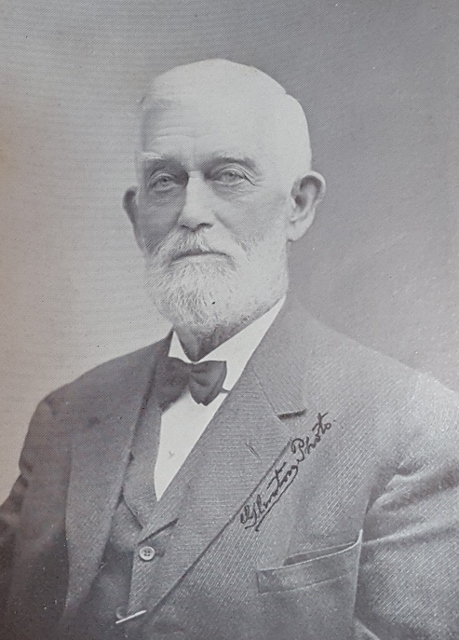
Kimball Webster 1912

Five Daughters of Kimball and Abiah Webster
Disasters known as “Freshets” and Fires
This week a brief look at the floods of 1896 and 1936 as well as the Crown Hill Fire in 1930 and how Hudson residents became spectators to these events.

Flood Watching on Iron Bridge 1896
Floods, or ‘freshets’ as referred to by Kimball Webster in his History of Hudson, were common events along the Merrimack River and were recorded in his history of our town. This is particularly true in the bridge area with the mouth of the Nashua River just a few rods to the north. Coupling this with the spring rain fall along with snow and ice melting from the north and west contributes to flooding and the potential for the destruction of property. In the 1800’s notable freshets were recorded in 1818, 1824, 1839, 1841, 1843, 1852, and 1862. In April 1895 a freshet occurred which raised the river to a higher point than any for many years. The east bank of the Merrimack opposite the Nashua River overflowed and covered land along Webster Street.
Our first photograph shows residents of Hudson watching the flood water of the river from the recently constructed iron bridge during the freshet of March 1896. Just before midnight on March 2 the river gained its highest point and began, slowly at first, to recede. The weather turned colder the next day allowing the water to fall very rapidly. At the highest point the water covered all of Webster Street directly west of Kimball Webster’s house. The flood water rose to within six feet, six and one half inches from the underpinning of his house near the front door. Near the iron bridge the surface of the flood was between three and four feet below the floor of the bridge.
On Sunday May 4, 1930, in the early years of the depression, many Nashua residents were suddenly made homeless by a huge fire which destroyed the Crown Hill residential area. This area was East Hollis and Allds Streets eastward to the bank of the Merrimack River, just a short distance south of the Taylor Falls bridge in the area of the railroad bridge.
The blaze began in a trestle of the B & M Railroad where it spanned the Nashua River off Temple Street. High winds escalated the blaze and carried the fire across Temple, down Spruce, and across East Hollis Streets to the Crown Hill area. Fire equipment from surrounding towns in both New Hampshire and Mass. came to assist. Individual residents pitched in with bucket brigades, shovels of dirt, and even blankets. In the end some 400 homes were destroyed and that section of Nashua reduced to wasteland. Most of the property owners had little or no insurance. One year after this disaster more than 400 homes were rebuilt and the area was making a comeback with new zoning and wider streets.

Hudson Residents Viewing Crown Hill Fire 1930
Homes and property in Hudson were protected from the spreading blaze by the Merrimack River; although there were some instances where sparks jumped the river, due to the severe winds, and had to be extinguished. As shown in our second photo, some Hudson residents set up their chairs along the Hudson side of the river and became spectators to the fire.
In March 1936 the most severe flood for this area occurred. By Thursday morning, March 19, the Taylor Falls Bridge was closed to traffic as the banks of the Merrimack were overflowing with tons of water on both sides of the river. At 7:00 A.M. the river was rising at the rate four feet per hour. Residents living near the bridge were forced to evacuate. Officers were stationed at both ends of the bridge to stop traffic.
Families along Webster Street and Litchfield Road were evacuated. The Paradise section near the river (Kenyon, Merrimack and Federal Streets) was completely flooded and the fire department evacuated residents by boats. In the areas mentioned, water rose to the first floor windows.Extensive flooding occurred at all homes along the Webster Street and Litchfield Road.
During the height of the flooding, a log coming down the river did so with such force that it banged head long into the railing of the cement Taylor Falls Bridge. This left a permanent hole in the railing, removing the concrete, and showing only the underlying mesh. From that day until the removal of the bridge, the damage was never repaired. It remained as a reminder of the of the potential force of the river current.

Flood Waters 1936
Again, our fellow residents of town chose to walk on the bridge and observe the flood water barreling into the bridge on it;s north side. Needless to say, this occurred either before or after the height of the flood. Water was ether receding or still trying to reach it’s maximum height. Our third photo shows Hudson residents leaning over the north side of the bridge as the flood water approached the bridge.
B+M Railroad Bridge blasted by Army manuevers – Dec 1942

B+M Railroad Bridge Crossing Into Hudson – 1938
The Worcester, Nashua, and Portland line of the Boston and Maine Railroad began operation through Hudson in 1874 and continued until abandoned in the early 1940’s. The railroad line entered Hudson by crossing the Merrimack River just south of the present Taylor Falls bridge between Nashua and Hudson. The line then took a gradual north and easterly path to Hudson Center and then on to West Windham.
The original wooden railroad bridge was completely destroyed by fire in June 1909 when sparks from an east bound freight train ignited one of the timbers. The resulting blaze was so spectacular that an estimated 1,000 folks in the area watch the blaze against the midnight sky. The destruction of this bridge seriously interfered with the traffic between Worcester and Portland; some 32 trains per day used this bridge daily along the single track line to West Windham and Portland. A temporary bridge was put in place within a week and a replacement steel bridge was completed in record time.
By December of 1942 the days of this line had ended. It was decided to use this steel railroad bridge for army maneuvers. On Saturday December 26, 1942 two preliminary blasts of dynamite were set off near the Nashua side of the bridge. These were staged to acquaint the military unit with the explosives. A detail from Maryland was delegated for this task. According to the Nashua Telegraph the Army Engineers planned at some later time to conduct extensive maneuvers ending with the blowing up of the bridge. According to officials of the railroad, the railroad bridge had been turned over to the U.S. Army about one month earlier.
These explosions occurred without warning to or previous planning with local officials. The first blast consisted of 50 pounds and a second of 150 pounds. Residents of the Crown Hill section of Nashua as well as of the Hudson Bridge area were frightened and hundreds of phone calls were made to police and fire headquarters as well as to the local paper. The resulting explosions rocked houses and blew out hundreds of panes of glass. Many residents were in a near panic and several women were hysterical.
Complaints and protests occurred on both sides of the river. Scores of residents from Crown Hill district reported window broken and other damage. On the Hudson side many windows were blown in and plaster was shaken down in many of the homes. Significant damage was reported to the windows and frames of the Hudson Community Church. The effects of the blasts were felt as far away and Benson’s Animal Farm in Hudson Center.
Needless to say both Nashua and Hudson officials registered their protests through Senators Bridges and Tobey. The senators conducted an investigation into the blasts. Army personnel from Fort Belvoir, MD as well as First Corps Area were called back for the session. First Army Corps of Boston claimed they had no prior knowledge of the maneuvers. No advance warning of the blasts had been given. Much, of the damage and emotions could have been controlled with advance knowledge of the blasts and simply opening the windows just prior to the last. Army officials met with Hudson Selectmen and property owners in order to access the damage. Shortly thereafter forms were provided to the property owners for reimbursement of damages. Reimbursement for at least part of the damages by the U.S. government did occur up to 1 year later.
Once the Senators and officials from Nashua and Hudson learned that these blasts were preliminary to blowing up the bridge with a 500 pound charge at some future time an official protest to further blasting was registered. It was pointed out that it made more sense to salvage the bridge for scrap material for the war effort than to blast it and sink it into the river.
In October 1943 salvaging of the bridge began when Governor of New Hampshire, Robert C. Blood, applied the torch to the first steel girder of the old railroad bridge. In the end, 500 tons of steel were scrapped and turned over to the State Salvage Commission to be used in the making of war materials. By January 1944 the old railroad bridge was gone. All that remains of this bridge today are the old abutments in the river, visible just south of the Taylor Falls Bridge.
This photo is from the Historical Society collection. It shows the railroad bridge during the hurricane of 1938; just a few years before the army maneuvers to blast the bridge. In this photo a train was stationed on the bridge during the hurricane to stabilize the bridge. Details of the blasts, resulting damage, and the probes were reported in the Nashua Telegraph for Monday December 28, 1942.
Scottie Industries on Roosevelt Avenue

Scottie Industries Roosevelt Ave. C 1975
Frank A. Winn Farm on Lowell Road
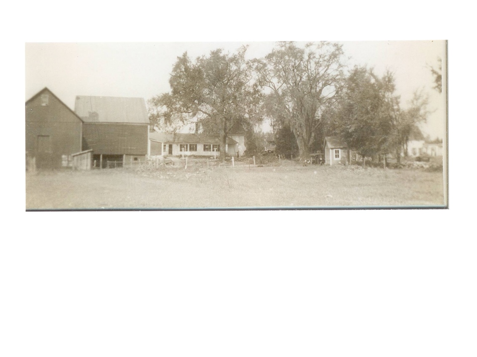
Home of Frank A, and Effie May Winn
