Home » Cemeteries

Category Archives: Cemeteries

Search for Rev. Benjamin Dean

The Reverend Benjamin Dean moved to town in April 1828 when he became the pastor of the Baptist Church of Nottingham West (now Hudson). We know only a few details of his life before that time. Born in northwestern Massachusetts about 1793 he was ordained at Swanzy, NH in February 1826. Just prior to Hudson he was serving as an Evangelist for the Baptist Society in Westmoreland, NH. Most of his time with the Hudson church was a dark and difficult time. In less than 2 years his connection with the church was terminated as he was deposed by an ecclesiastical council and excluded from the church for immoral conduct. I have no further details about the claims brought against him. To Mr. Dean’s credit it is only fair to say that by 1834 he made a public concession of his wrongdoing and asked forgiveness of both the Baptist and the Presbyterians. You see, at that time both churches were worshipping in two meeting houses at different times; the North meeting house (near Wattannick Hall) and the South meeting house (near Blodgett Cemetery). A short while later he was restored to membership in the Baptist Church; he never returned to the ministry but did reside and work in the Hudson Center community.

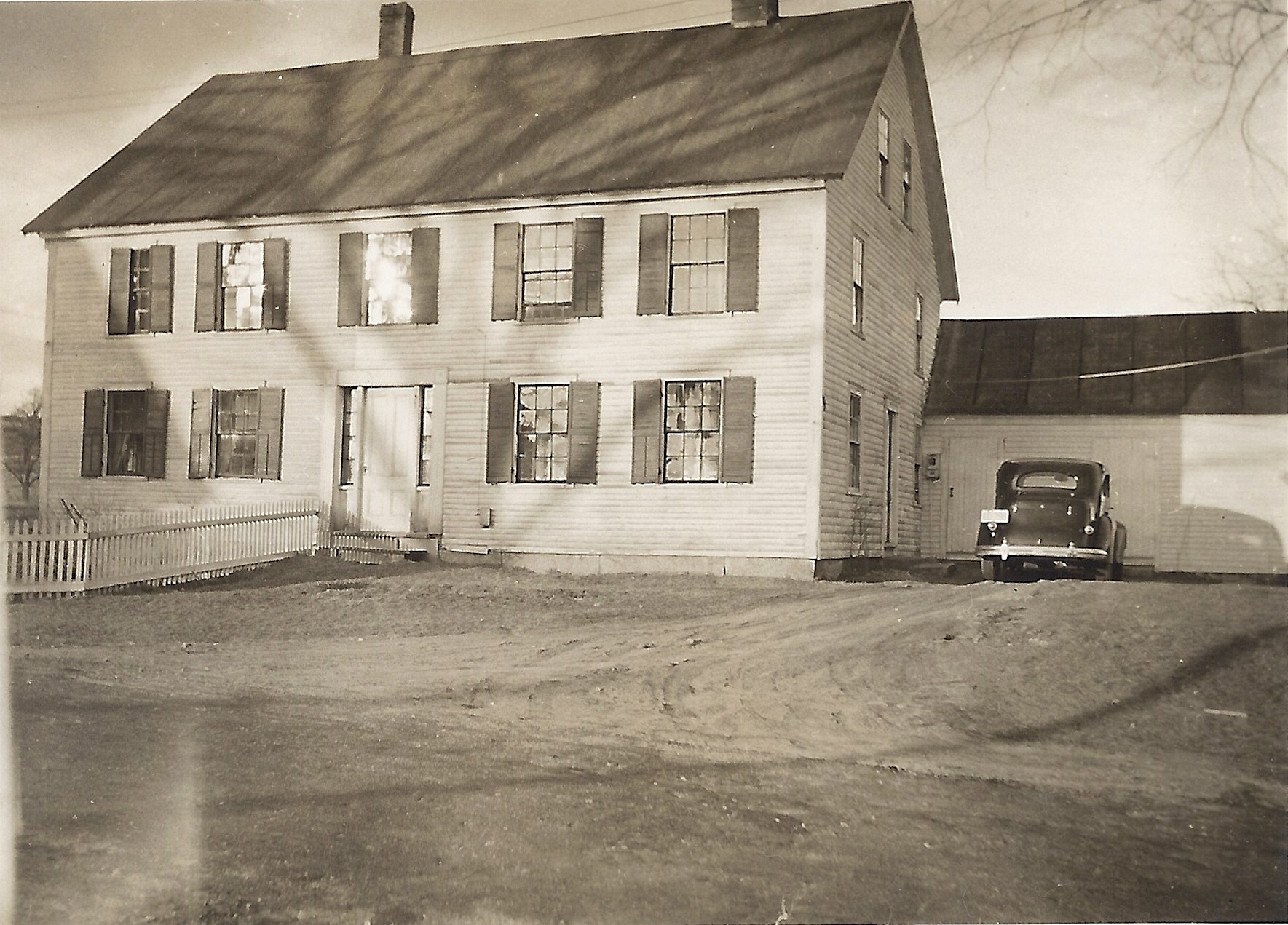
Benjamin Dean House on Hamblet Avenue C 1942

The Benjamin Dean house which was located on Hamblet Avenue is known as “The House Twice Moved”. This house was built by Abraham Page in 1747 on the Bush Hill Road and it later became a part of the Haselton Farm. By 1836 the owner, Benjamin Dean, moved the house down to Hudson Center on the east side of the Hudson Center common and a short distance from the North Meeting house where he had once preached. He married Betsey Hadley of Hudson in 1843. The US Census records, and the 1855 Diary of Eli Hamblett give us a sense of Hudson Center at the time. Eli and Benjamin were neighbors, owning the only houses on Hamblett Avenue. Dean often worked for Hamblet in exchange for farm produce. Agricultural lectures and school were sometimes held in Deans Hall; a large room with an arched ceiling on the second floor of Dean’s home.

The census records gave me a clue that he passed between 1850 and 1860. Whenever I searched for his date of death and where he was interred, I hit a brick wall. As it turns out he passed in December 14, 1856 and was interred in the early potter’s section of Westview Cemetery; burial places set aside for the indigent. The “rest of this story” has more to do with how this information made itself known to me than the facts themselves! The information came from two documents; one a part of the Historical Society collection and the second the old Westview Cemetery record book.

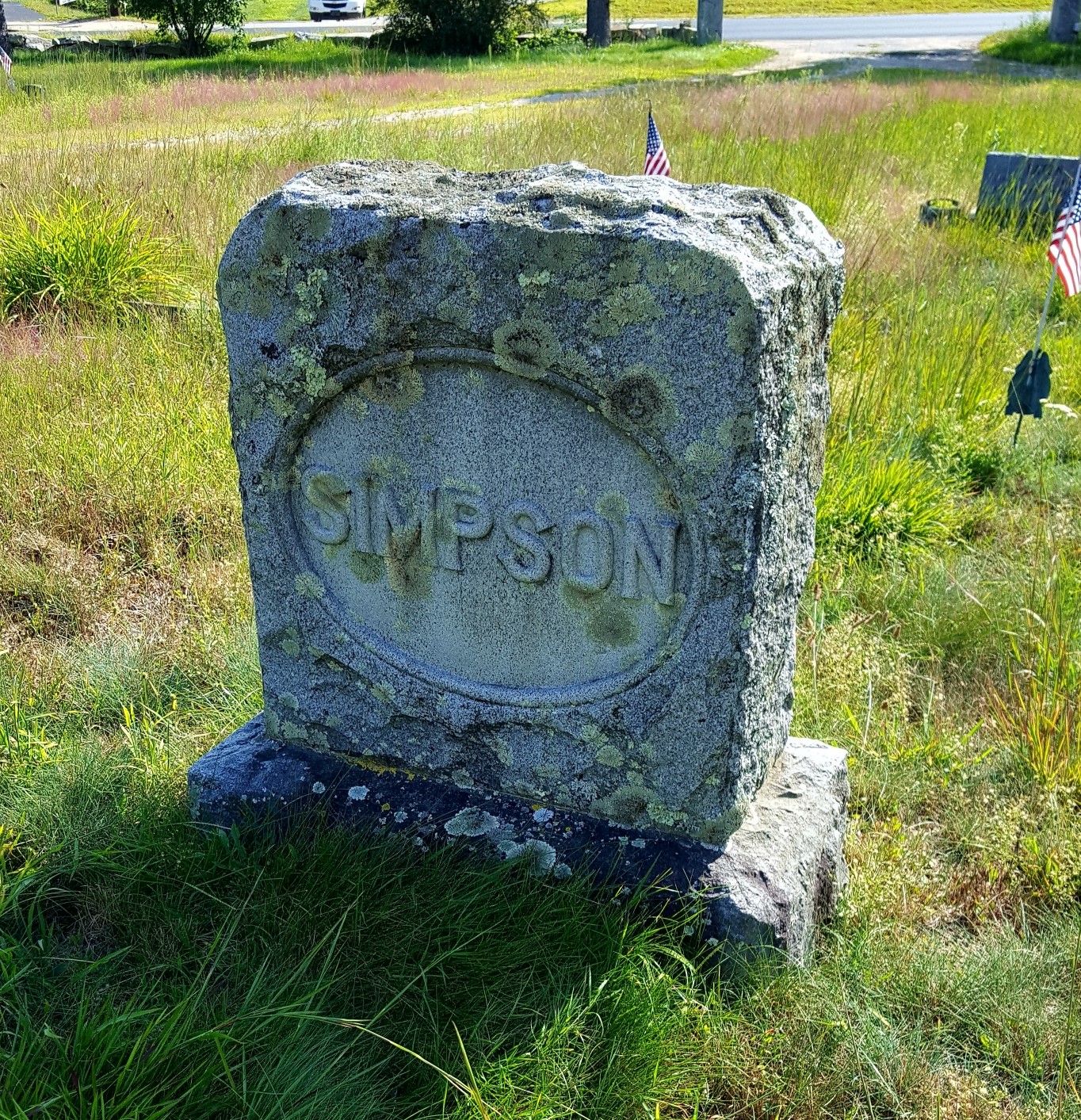
From a work ledger (1840 to 1865) kept by Eli Hamblet I learned that on December 14, 1856 he recorded a charge of $1.40 against the Estate of Benjamin Dean for taking his team to Nashua for a coffin and for sexton duties. Since Hamblet had a definite connection with Westview Cemetery I had reason to think Rev. Dean was buried there. This work document came into possession of the Society just a few years ago; it had been in a private collection and the donor wished that it be returned to this town!! Later, while doing some cemetery research on lot 76 (the Simpson family lot) I had reason to look up that lot in the old record book. Two thirds of the present day lot were once a part of the potter’s field which had remained unused except for one grave, that of Rev. Benjamin Dean. This fact had been lost from the records when the new book was started about 1900. I quickly looked at the layout of lot 76 in the current record book. The center of the lot shows the outline of the Simpson family monument superimposed over an outline of a coffin. I knew where Rev Dean was laid to rest! This information has been incorporated into the current cemetery records and steps will be taken for the site to be marked.

The (unmarked) Grave Site of Rev. Dean

A dear friend of mine once said, “if you are looking for information about someone and that person (past or present) wished to be discovered they will assist you by making the information available to you. This may seem “spookey” but in this case with Rev. Dean this omen is true! The photo of the Dean House is from the collection of the Historical Society. That of the gravesite was taken by the author.  Researched and written by Ruth Parker


Cemetery of the Unknown

Peremiter fence cemetery of unknown

Perimeter Fence

The Cemetery of the Unknown was a part of the town poor farm  located in the north west section of Hudson on what is now Old Derry Road.  For this cemetery there are no monuments, no headstones, and no records to identify the individuals buried there.  The farm was purchased by the town in 1828 in the days when the resident poor were kept at the town farm.  Those who could worked the farm in an effort to produce food for all residents on the farm.  The town maintained this farm for some  40 years until 1868 .  At that time the farm was sold and the few paupers which did exist at the time were boarded out to private homes at the expense of the town. The  only known records of activity at the town farm was recorded by the Overseer of the Poor in the annual town reports.  It is estimated from these records that over the course of 40 years the  number of residents at this farm varied from 6 to 12 per year.   Any of them who spent their final months at the farm likely found their final resting place within the Cemetery of Unknown.  Some of these folks had been prosperous citizens of Hudson  but due to reversal of fortune  or conditions, spent their final times here and were laid to rest in the yard at the end of the farm.
The number of deaths which occurred here during these 40 plus years in not known; but it is estimated there was an average of at least 1 per year.  There are no records to indicate who they are, when they passed, and where within the cemetery each was laid to rest.
As time progressed  the land upon which the burial yard existed continued in private use.  Fewer and fewer residents of town retained any memory of this cemetery.  Perhaps the stage was set for the Cemetery of the Unknown to be lost to history forever.
100 years after the town poor farm and the site of the Cemetery of the Unknown was sold by the town of Hudson, Paul Gauvreau and his family purchased their homestead on Old Derry Road.  In talking with family of the previous owner, Paul was told about the Cemetery of the Unknown and that only a few people were still alive to remember that it existed; soon it would be grown over and all traces of the cemetery gone forever.
In 1982 plans were made to construct a new road, Twin Meadow Drive, and to build a number of duplex residences.   Aware of the existence of the cemetery but not sure of it’s exact location, Paul informed the Hudson Planning Board of the cemetery.  The developer agreed to stop excavation if burial sites were unearthed.  None were found and several duplexes were constructed along Twin Meadow Drive bordering the  field off Old Derry Road.
In 1990, Paul along with some of the  neighbors on Twin Meadow Drive did some local detective work  in the fields behind Twin Meadow Drive.  After removing brush and mowing the tall grass on a flatter section of the field, they discovered what appeared to be several sunken grave sites.  These depressions measured about 2 1/2 feet wide and about 6 feet in length and faced east and west; consistent with grave sites.  The depressions were likely caused by the collapse of the wooden enclosures over the years.  Paul contacted the town Executive Administrator, town Planner, and the Town Librarian .  Upon visiting the site, all agreed the site was worthy of further study; but, since the form of town government was about to change, all agreed to postpone the matter until the new government was in place.
Paul researched the Hudson town reports for the years 1845 through 1870; specifically the Reports of the Overseers of The Poor which lists the activities and financial transactions of the Poor Farm.  It should be noted that reports from 1828 through 1844 were not available.  He was able to compile a list of some 32 names of  individuals that died as paupers associated with the poor farm during these years, either living at the farm or being boarded in private homes at town expense.  Of these 32, 3 were buried in Nashua or Litchfield.  Most, if not all if the remaining 29 were buried on the farm. It is not possible to discover the exact number or identity of the individuals laid to rest in this cemetery during it’s 42 years of operation. The names we do have include individuals from well known Hudson families:  Barrett, Hamblet, Johnson, Marsh, Parker, Robinson to name a few.
In August 1994, as agreed with the town officials, Paul contacted Mr. Gary Hume, State Archaeologist, and asked him to conduct archaeological probings.  These probings and investigations took place during the fall months of 1994.  Present at each of these sessions were representatives from the state, officials from Town of Hudson, the Historical Society, various neighbors in the area, and Paul Gauvreau.  Paul had previously shared the results of his findings with both town and state representatives.  In March 1996, the New Hampshire Division of Historical Resources issued a report of their findings to Hudson Cemetery Trustees.  In essence this report confirmed the location and existence of the Cemetery of the Unknown.  The report did not make specific recommendations as to how this cemetery should be preserved; but did direct the town of Hudson to proceed with the recognition and protection of the property. In the months to follow, the town of Hudson led by the Cemetery Trustees, purchased from the landowners the Cemetery of the Unknown (also known as Poor Farm Cemetery) along with an access easement from Twin Meadow Drive to the cemetery.  On September 1, 2007 the cemetery was dedicated and a single monument placed there in memory of the estimated 62 individuals buried there over the years.
Monument at cemetery of unknown s

Single Monument for All 62 Nameless

The author and Paul Gauvreau visited the cemetery this past weekend and met with Susan Bauman whose home abuts the cemetery.  Both Paul and Susan have maintained chronology of events leading up to the confirmation and dedication of this cemetery.  Our thanks to them for sharing information with us.

Holy Cross Cemetery on Ledge Road

Holy Cross Cemetery S

Entry Sign and Flagpoles at Holy Cross Cemetery in Hudson


The Church of the Immaculate Conception at what is now 119 Temple Street, Nashua was consecrated in 1857 as an Irish Catholic Community. By the early 1900’s the Lithuanian Community was on the increase and a pastor was added to this church to minister to them. As both communities continued to grow it became evident that a new church was needed. By 1909 the Irish Community moved into the newly constructed Saint Patrick’s Church on Spring Street. Soon thereafter The Church of the Immaculate Conception was transferred to the Lithuanian Community and the name of the church changed to Saint Casimir’s in honor of the Lithuanian saint.

One of the first additions made by Saint Casimir’s church was the purchase of property on Ledge Road in Hudson for a cemetery; Holy Cross Cemetery. At the entrance to this cemetery from Ledge Road there are two flagpoles: one flies the US Flag the other the Lithuanian Flag.

Saint Casimer’s church was closed in 2003 and the congregation merged into Saint Patrick’s on Spring Street. The property at 119 is now Casimir’s Place, an affordable housing complex. Holy Cross cemetery retains it’s original name but the management and operations have been combined with Saint Patrick’s Cemetery. In a sense the congregations of Saint Patrick’s and Saint Casimir’s have gone full circle. Originally the Irish and Lithuanian congregations shared The Church of the Imaculate Conception on Temple Street. As congregations grew, the Saint Patrick’s Church was built on Spring Street and the Lithuanian community remained on Temple Street as Saint Casimir’s. Some 90 plus years later in 2003, Saint Casimir’s has merged with Saint Patrick’s.

Initially this cemetery offered burial space to members of the Lithuanian community. Until recently the policy of this cemetery was to offer burial space to members of the Catholic community. This has changed and space within Holy Cross, like Saint Patrick’s, is available to any member of the Christian community. The contact person is Elaine Poulin at 881-8131.

The photo of the entrance to Holy Cross was taken by the author and is part of the Historical Society collection.

The Catholic Cemetery (Saint Patrick’s) on Derry Road

St Patricks Cemetery Entry S

St Patricks Cemetery Derry Road

The availability of jobs resulting from industry and factories coming to Nashua resulted in an increase in the immigrant population of Nashua.  The Catholic Church quickly recognized the need to have pastors and congregations available for these communities.  In the 1850’s Nashua experienced a great influx of Irish families, pushing the construction of The Church of the Immaculate Conception on Temple Street.  At the time of it’s consecration in  1857,  2,000 communicants were added to the church rolls. 

By the early 1900’s the Lithuanian Community was likewise on the increase and a pastor was added to The Church of the Immaculate Conception  to minister to them.  As both communities continued to grow it became evident that a new church was needed.  In March 1891 the church purchased the Hosmer Estate on Spring Street and by 1909  services were being held for the Irish Catholic Community at Saint Patrick’s Church on Spring Street.    
 
Soon after 1909 The  Church of the Immaculate Conception  was turned over to the Lithuanian Community and the name of the church changed to Saint Casimir’s.
 
 On or about 1857 ten acres of land on Derry Road in Hudson was purchased  by The Church of the Immaculate Conception and consecrated for the purpose of a cemetery for the Irish community.   The original land was conveyed by the Pierce Family of, James L, John P, and Edgar B, residents of Nashua.  With the exception of about one acre on the east side which was swampy and unfit for use as a cemetery, lots were laid out. In 1907, a strip of land was purchased on the north side and an enlargement made to the cemetery. By 1912, at the time of the writing of Webster’s History of Hudson, nearly all the lots had been taken up.  The vast majority of the interments within this cemetery were for families residing outside of Hudson. Our first photo shows the hillside as you enter the cemetery.  After the archway with the name of the cemetery is the sacred cross followed by the War Memorial and the American Flag.
Celtic Cross St Patricks

Celtic Cross at St Patricks

 
Acting as a sentinel and gateway to the newer section of the cemetery behind Hannaford’s Super Market is this Celtic Cross, in memory of  R. T.  Rev. Monsignor Matthew J.B.Creamer, the Pastor of St. Patrick’s Church from 1906 – 1939.  
 
Initially this cemetery was to offer cemetery space to members of the Irish community.  By 1895, the Catholic cemetery contained about 4,000 graves sites; the vast majority were for the Irish Catholic community, but a few hundred French Catholics were also interred here.  After St. Patrick’s  Church on Spring Street was built the name of this cemetery was changed to Saint Patrick’s.  Until recently the policy of this cemetery was to offer burial space to members of the Catholic community.  This has changed and space within Saint Patrick’s is available to any member of the Christian community.  With the recent expansion there are lots available.  The contact person is Elaine Poulin at 881-8131.  


Westview Cemetery on Burnham Road

OLYMPUS DIGITAL CAMERA

Westview Cemetery Burnham Road


When the Old Hudson Center Cemetery, located on the Common, became nearly covered with graves, the need for additional  cemetery  space in that part of town became apparent.  The Hudson Center Cemetery Association published their intentions on the Oasis, a newspaper published in Nashua for three weeks in a row, in accordance with the laws of the State of New Hampshire.  An initial meeting was held at the town house in Hudson Center, now Wattannick Hall, on December 4, 1849.  At this meeting a set of by-laws and a slate of officers were elected.  Elected as Directors were Jefferson Smith, Joseph Dane, James Smith, 2nd, Dustin B. Smith, and Daniel W. Robinson,  Eli Hamblet was elected Clerk and Amory Burnham as Treasurer.


The initial acreage for the cemetery was donated by Reuben Greeley.  This parcel is located to the right as you enter the cemetery gate from Burnham Road.  The cemetery was laid out into large lots, most of which would allow for 12 burials so as to accommodate large families and multiple generations.  Between each lot space was allocated for walkways.  The layout also included streets wide enough so that  horse and wagons, and  later vehicles could enter the cemetery.  All of this was located less than one half mile from Hudson Center.


After the Nashua and Rochester Railroad was constructed, a substantial addition of land was made to the cemetery.  All the land between the initial parcel and the southerly line of the railroad land was acquired, making a total of nearly three acres.  After the railroad ceased to operate, the cemetery purchased  the right of way from the railroad.  This right of way is clearly visible today and is used as a short cut from Burnham Road to Hudson Center.


So as not to confuse this new cemetery with the Old Hudson Center Cemetery it was called Clement Cemetery.  I am not sure why this name was associated with this yard; but, it is often referred as such in the old records.  The name Westview has since been adopted and it is known by that name today.


Within this cemetery one will find the final resting place for many Hudson families of the last 167 years.  One will also find a number of lots with beautiful and expensive monuments; as well many of the more common markings.  Records of the cemetery also indicate burials in some of the lots where no visual monuments were placed by the surviving families.  But, thankfully, knowledge of their burials has been preserved by the written records.


I find the most elaborate monuments within Westview to be along the back wall of the old section.  These belong to the families of Dr. David O. Smith, Dr. Henry O. Smith, and the Haselton family from Bush Hill.  The oldest burial is that of Betsey Beard who died June 1850 at the age of 80.


The most  interesting burial site is the unmarked grave of Rev. Benjamin Dean, a minister serving the Baptist Church from April 1828 to June 1830; at which time he left the ministry but remained a resident of Hudson Center and continued to live in  his home on Hamblet Avenue.  When he passed in 1856 he was buried in the Potters Field section of the cemetery.  Many years later when additional lots were laid out, the Potters Field and his burial site was included within one of the new lots.  But, the location of Rev. Dean’s burial site has not been lost to history.  It remains unmarked; but, has been included within the written record of this newer lot.


The photo showing the entrance to Westview Cemetery at 20 Burnam Road was taken by the author and is a part of the Historical Society Collection.

Sunnyside Cemetery on Central Street

Sunnyside Entrance S

Entrance to Sunnyside Cemetery on Central Street

As the town grew and burial space in the older cemeteries became limited, the need for Sunnyside Cemetery arose.  According to the incorporation papers the legal name of this yard is ‘The Hudson Cemetery”.  The Sunnyside cemetery as it is commonly refereed to is located on the north side of the highway at 98 Central Street.   According to records, the original yard purchased from William Hadley in June 1846 was slightly over 1/2 acre.  The land was purchased for $13.00 and an additional $257.00 to Ethan Willoughby for the construction of the stone wall which enclosed the yard with an entrance off Central Street.  There were two  additional land purchases, one in 1885 and the second in 1910.  After the first purchase the stone wall was moved to include the parcel within the bounds of the yard.  At the present time this small cemetery contains 2.817 acres shaded from the canopy of maple trees.
According to Kimball Webster in his History of Hudson,  the first meeting of the Hudson Cemetery Association was held at the home of Ethan Willoughby on Central Street  December 6, 1845.  At this meeting the cemetery was organized, and the articles of association were signed by Ethan willoughby, Paul Colburn, Cyrus Warren, Nathan Marshall, William Hadley, David Clement, David Burns, Abiather Winn, Mark Willoughby, Benjamin A. Merril, and William Blodgett,  It was also agreed to purchase the original 200 by 113 feet original parcel for the cemetery.  No record of any subsequent meeting for several years; however business was conducted and the land was purchased, lots laid out,  and stone wall built  by 1851.  
 
The very first lot, number 17, was sold to Alfred Cummings on April 8, 1851.  By 1885 all the lots in the cemetery had been sold and during that same year a second land purchase of 1 acre was added to the cemetery on the east side and the wall was moved so as to enclose it.  The new ground was laid out into lots and the size of the cemetery more than doubled.  By 1908 all the lots in this section had been sold.  Again in 1910, a 1/2 acre was purchased from George Marshall, allowing expansion to the rear of the cemetery.  this land was subsequently improved and laid out into lots, all of which have been sold.
Joseph Fuller Monument

Joseph Fuller Monument

Sunnyside  is an attractive cemetery with a convenient location.  It contains a number of expensive and interesting monuments.   To me, the most elaborate monument is that for the families of Kimball Webster and his Brother Nathan.  This monument greets you on the right as you enter the yard.  The most interesting monument is that for Joseph Fuller (1818-1896) and his wife Belinda Steele (1823- 1891).  This metal monument is shown in our second photograph and  resembles a fireplace.  It is on the right side of the yard about halfway to the rear.
Unfortunately, the surrounding area does not include any possibility for expansion.  It has become the final resting place for many of Hudson’s families such as Baker, Batchelder, Chase, Colburn, Cummings, Davis, Gould, Hadley, Holmes, Martin, Marshall, Pollard, Sanders, Sargent, Stearns, Steele, Willoughby, Winn, and Webster.  At the present time the management of Sunnyside Cemetery in handled by Fred Fuller.
The photo of the entrance to Sunnyside was taken by Lorna Granger, a neighbor to the cemetery.  The photo of the Joseph Fuller monument was by the author.  Both will be part of the Society’s collection.

.. Hudson Center Cemetery

Hudson Center Gate1

Hudson Center Cemetery Gate

Actually, the next Hudson cemetery in terms of age is the Senter cemetery which we visited a few weeks ago when we were exploring Old Derry Road,  Remember, interments at the Senter site occurred as early as 1759 while this part of Hudson was within the town of Londonderry.  It became a Hudson cemetery when annexed to Hudson in 1788.
The old burial ground at Hudson Center is a small site containing about 1/2 acre.   It was first used a s burial site about 1775.  This was a public burying ground, given for that purpose by Deacon Henry Hale from a small piece of his farm.  Following tradition, the burial ground was located near the North Meeting House.  Today, this ground is  on the lower, east corner of the Hudson Center Common, just above Kahil’s Sub Shop.  The North Meeting House was located opposite the common on Central Street, and very near the site of the current Wattannick Hall.
Kimball Webster in his Hudson History, printed in 1913, stated there was a verbal tradition among the old timers that the first internment made in this yard was a Mrs. Gibson.  There is not such stone in the yard, probably none was erected.  Other than this possibility, the oldest date found here is that of John Haselton Smith, son of Page and Lydia Smith,, who died September 5, 1778 at the age of two,  This yard became filled with graves as early as 1850; and few, if any, burials have been made there since that date. It is estimated the unmarked graves within this yard out number those with headstones by as much as 200-300%.
 Once burials ceased to be made, it became neglected and suffered from brush and trees so that it became a disgrace to the residents of Hudson,  A petition  suggesting the removal of the remains probably moving then to another cemetery.  In 1871 a special town meeting was called at which this petition was dismissed.  In 1886, Mr. John Foster of Boston, a native of Hudson, made a proposition to the town.  He would  pay the expenses of building a substantial and permanent granite wall enclosing the yard on the condition that the town would clean up the ground and to keep the site in a good condition.  His proposition was accepted  and in 1887 the current wall was erected.  It has ever since that time been maintained by the town of Hudson.
Center Sign

Foster Family Memorial Sign

A memorial plaque exists to the right of the game as a memorial for the wall to his parents. Today this is done by the Highway Dept. and the town cemetery trustees.  A few years after 1887 the fir trees were added to the Common beside the cemetery wall.
Today’s photos were taken in 2017 by Jonathan Rollins and are a part of the Society collection.

Blodgett Cemetery


Blodgett Cemetery

Blodgett Gate at Pelham and Lowell Roads

Our next cemetery to visit is the Blodgett Cemetery, located on Pelham Road at the intersection with Lowell Road and about 1 1/2 miles south of the Taylor Falls and Memorial Bridges. It is the third burial yard, in order of age, in Hudson. It contains about 1 acre of land and was acquired by the town on or before 1748 from Benjamin Whittemore for a meeting house and public uses. The state boundary with Massachusetts was established in 1746, leaving the residents of town in need of a meeting house site more central to it’s people. This site was selected and by 1748 the second meeting house was erected by the town. Kimball Webster in his History of Hudson describes the site of the meeting house as on the south side of the yard and near the present gate of the cemetery. The burial plots were the church yard, surrounding the house on the rear and on both ends.

In time the meeting house was moved away, and the No 4 school house built on the site. By the winter of 1855 the school house burned. Prior to this time a question was raised about the town’s title to this lot on the north side. At the town meeting of 1839 the town appointed a special committee of Thomas Wason, Jeremiah Smith, and Daniel Davis to investigate. This committee met with Reuban Greeley, Esq. the abutter on the north end. After this meeting, all parties agreed to establish an east west boundary on the north side of the town owned land.

After the schoolhouse fire in 1855 that site was abandoned in favor of a location nearby. As the land upon which the schoolhouse had stood belonged to the town it was added to the cemetery and a short time later a cemetery association was organized. The yard was then enclosed by a stone wall with an iron gate. The grounds were cleared of bushes and rubbish and other improvements were made. Family lots were located and laid out using the vacant grounds. Unfortunately, either from carelessness or willfulness, new lots were plotted upon grounds of some ancient graves and they were obliterated. In Webster’s History he reported this as inexcusable and lacking the respect which should have been due to these early settlers.

The most ancient date found among the inscriptions of this place is that of Priscilla Chase who passed October 5, 1749. The most frequent surnames found on the headstones are Blodgett, Greeley, Burns, Chase, Pollard, Winn, Wason, Hale, Caldwell, Page, Wilson, Cross, Merrill, and Burbank.

Within this cemetery are four generations of Blodgetts with the name Joseph. Joseph, born 1760, served in the Battle of Bennington in 1777. Being a lad of 17 he did not receive credit for his service at either the local or the national level until 2007, some 229 years later. His service has since been registered at the national level by Ruth (Baldwin) Williams, a descendant of his from Oak Forest, IL. when she applied for membership is the Daughters of the American Revolution (DAR). Young Joseph served with his father and the records for his service were credited to his father. His grave site in Blodgett Cemetery received a Revolutionary Soldier marker at a Memorial Day ceremony in 2007. Mrs. Williams coordinated this event with the Cemetery trustees, the American Legion of Hudson, and the Hudson Historical Society.

The photo shows the gate into this cemetery in 2007 and is part of the Historical Society collection.

Ford Cemetery at Musquash Road

Ford Cemetery S

Entrance Gate Ford Cemetery

The Ford cemetery is located on Musquash Road less than 1/4 mile south of  the site of the first meetinghouse of Nottingham. and on the same side of the road.   The location of the meetinghouse is at the entrance to the  Musquash Conservation Area and is identified by a granite marker.  This  cemetery, also known as the South End cemetery and the Musquash cemetery,  was laid out and dedicated as a burial place in 1734, just a short time after the building of the meetinghouse.
The custom of the early settlers in this part of New England was to have a public burying ground, or church yard as often called, connected to and often times surrounding it on three sides of the meeting house..  This was not practical at this location because the land in that vicinity was rocky and ledgy, not suitable as a place for the internment of the dead.  The selected site is as near the church as as a suitable plot of ground could be found.
To locate this cemetery one needs only to travel south on Musquash from the conservation area less that 1/4 mile.  On your left you will find a gravel driveway; the cemetery will be found a short distance in on this driveway.  Be careful as the cemetery cannot be easily seen from Musquash Road.  This burying ground contains about 1/4 acre, enclosed by a stone wall with an iron gate.  Above the iron gate is perched a long granite post laying horizontal  with the ground and supported on each side buy a similar granite post.  You walk under this post as you open the gate to enter the cemetery.
The most frequent names found within this yard are Snow, Merrill, Ford, Fuller, Gowing, Barron, Wilson, and Connell.
There is no debate as to the antiquity of this place; in fact some historians have claimed that it is the most ancient of all Hudson;s cemeteries.  The earliest date found in this yard is that on the headstone of Ensigh John Snow, “who departed this life March the 28th, A.D., 1735.  Aged 68 years, 4 month, and 3 days.  This headstone is a very thick, wide and heavy one and not very high.  This is the most ancient inscription of any, not only in this yard, it also predates the earliest date of 1738 found in Hills Farm cemetery or any other cemetery in town.  Ensign John Snow resided nearly on Musquash Road.  The first town meeting of Nottingham, MA  was held at his house on May 1, 1733.
This yard is the final resting place of Rev. Nathaniel Merrill, the first minister settled in this town. and his wife Betsey. He preached here for more than 50 years.
Without a doubt the most intriguing headstone within this yard is the double stone indicating the death of Capt. Thomas Colburn, age 63, and his 3 year old son, Thomas.  Both were killed on August 30, 1765 while asleep in their bed by a single flash of lightening.
The most recent, and I believe the last, internment to be made in this place, were those of Leslie Shunaman (died 2005)  and his wife Leslie (dield 2004).  Louise and Leslie were well known residents of Hudson and life members of the Historical Society.
I have a mystery concerning this cemetery and perhaps some of our readers can help!  Allen Morgan grew up in South Hudson and recalls visiting this cemetery with some of his ‘buddies’.  He recalls an inscription within this cemetery which reads “here lies the body of x who was lost at sea and never found”.  I have searched the cemetery and the inscriptions printed in 1908 by Kimball Webster and can find no reference to this!!  If anyone has an idea they can sent email to Ruth at HudsonHistorical@live.com or leave a message at 880-2020.

Hills Farm Cemetery

Cemetery Roadway S

Cemetery and Chapel Gate

There are  eleven cemeteries or burial places in Hudson.  They are Hills Farm, Ford, Blodgett, Hudson Center, Senter, Sunnyside, Westview, St. Pattrick, Holy Cross, Cemetery of the Unknown, and the Presentation of Mary’s cemetery.  Last week we looked at the Senter Burying Ground at Potash Corner.  This week we will visit the  Hills Farm Cemetery.
Early settlements of Dunstable, MA (now Hudson) clustered around the Hills Garrison in the north and the Blodgett Garrison in the south end of town.  The earliest of these  occurred about 1710 when three sons of Samuel  Hills (Nathaniel, Henry, and James) erected and settled in the Hills Garrison. The original part of the Hills Farm cemetery was located on level, sandy land about half way between what is now the Derry and Litchfield Roads and adjacent to Derry Lane.  This was the south-east corner of the Hills farm where Nathaniel and his brothers settled.  The exact date when this cemetery was first used as a burial place is not known but must have been some years after the Hills brothers settled at the garrison, and probably not earlier than about 1730.  It is known that Nathaniel Hills buried two or three of his children in the in the ancient burial ground in South Nashua near the entrance to Royal Ridge Mall.   The early settlers seldom erected head stones to identify the graves of their deceased loved ones; so, the markings we do find do not indicate the earliest interments.
The earliest  date found in this cemetery is 1738, crudely cut into a common stone with no inscription to indicate the individual interred there.  The next date found is that found in the inscription found on a headstone for  Joseph Greele , who departed this life March 7, 1745, in his 95th year.
Even though this cemetery was on the Hills property  and likely laid out by Nathaniel Hills it was it was used as a public burial place.  The early families of Hudson found among the headstones include Hills, Greeley, Spalding, Marsh, Marshall, Pierce, Cross, and Sprake.
About 1872 small additions of adjacent land were added to the cemetery.  These additions with some other vacant land in the yard were laid out into lots, streets were graded, the brush removed, and other improvements were made thus improving the overall appearance of the cemetery.  The cemetery contained a little less than one and one half acres.  In 1885, as permitted by state laws, the yard was incorperated as “The Farms Cemetery’  The charter was amended in 1905, changing the name to “Hills Farms Cemetery”.  About this time Dr. Alfred K. Hills, realizing the need for expansion of the cemetery, purchased a large tract of land adjacent to the cemetery and extending to the Derry Road.  He then had six acres of this parcel surveyed for an addition to the cemetery.  Upon part of the remaining land Dr. Hills built Alvirne Memorial Chapel in 1908 as a memorial for his wife Virginia.
Cemetery and Chapel Gate S

Roadway to Hills Farm

At the present time the Alvirne Chapel and the main entrance to Hills Farm Cemetery share access  from 160 Derry Road.  There is a secondary entry to the cemetery from Derry Lane.  The entrance from Derry Road is through an iron gate between two granite posts  inscribed  with Hills Farm Cemetery on one and Alvirne Memorial Chapel on the other.  Access to the cemetery is then through a right of way through  the parking lot to a shaded, wooden drive which takes you to the cemetery.  Hills Farm Cemetery is incorporated and under the management and direction of a Board of Trustees. This cemetery is open for new burials and there are lots available for purchase.  The contact person for the cemetery is George LaRocque.   The photos were taken by the author.